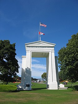
| Peace Arch Park | |
|---|---|
 Peace Arch Park, seen from the Canadian side | |
 | |
| Location | Canada and United States |
| Nearest city | Blaine, Washington/Surrey, British Columbia |
| Coordinates | 49°00′07.5″N 122°45′24″W / 49.002083°N 122.75667°W |
| Area | Canada: 22 acres (8.9 ha) U.S.: 20 acres (8.1 ha) |
| Established | November 7, 1939 |
| Governing body | Canada: BC Parks U.S.: Washington State Parks |
| Peace Arch | |
|---|---|
 The Peace Arch from the U.S. side. | |
| Height | 67 feet (20 m) |
| Built | 1921 |
| Architect | Harvey Wiley Corbett |
| Architectural style(s) | Classical Revival |
| Designated | December 13, 1996 |
| Reference no. | 96001493 [1] |


Peace Arch Park is an international park consisting of Peace Arch Historical State Park in Washington, United States and Peace Arch Provincial Park in British Columbia, Canada. The park straddles the international boundary between the two countries at the extreme western end of the main contiguous section of the two countries' land border, between Blaine, Washington, United States, and Surrey, British Columbia, Canada, where it reaches Semiahmoo Bay of the Salish Sea on the continent's Pacific Coast.[2]
The park's central feature is the Peace Arch (French: Arche de la Paix). Construction of the 20.5-meter (67 ft) tall arch was headed by American lawyer Sam Hill and dedicated in September 1921. The Peace Arch commemorates the signing of the Treaty of Ghent in 1814 and symbolizes a long history of peace between the two nations. The monument is built on the exact U.S.–Canada boundary, where Interstate 5 on the U.S. side of the border becomes Highway 99 on the Canadian side, in the grass median between the northbound and southbound lanes.
The park is located at the Peace Arch Border Crossing (also known as the Blaine–Douglas Border Crossing), where Highway 99 in British Columbia and Interstate 5 in Washington State meet. It is one of the busiest border crossings between Canada and the United States, and the busiest such crossing west of Detroit. The park's northern portion is about 9 hectares (22 acres) and is managed by the British Columbia Ministry of Environment.[3] The southern portion is about 20 acres (8.1 ha) and is managed by the Washington State Parks and Recreation Commission.[4]
About 500,000 people visit the Peace Arch each year.[5] The monument and surrounding park is considered an international park. As such, visitors do not require either a passport or visa to pass through their applicable border crossing so long as they stay within the boundaries of the park and leave the park into the country from which they entered the park.[6]
- ^ "National Register Information System". National Register of Historic Places. National Park Service. January 23, 2007.
- ^ Cite error: The named reference
detachedwas invoked but never defined (see the help page). - ^ Cite error: The named reference
bcparkswas invoked but never defined (see the help page). - ^ Cite error: The named reference
waspwas invoked but never defined (see the help page). - ^ "Peace Arch – City of Surrey Heritage Sites". www.surrey.ca. Retrieved December 31, 2016.
- ^ About Peace Arch Park Archived September 4, 2012, at the Wayback Machine