Peaceful Valley Historic District | |
 Typical homes in the district | |
| Location | Peaceful Valley, Spokane, Washington |
|---|---|
| Coordinates | 47°39′32.3″N 117°26′06.8″W / 47.658972°N 117.435222°W |
| Area | 39.9 acres (16.1 ha) |
| Built | 1890s-1940s |
| Architect | Multiple |
| Architectural style | Multiple |
| NRHP reference No. | 84003617[1] |
| Added to NRHP | April 19, 1984 |
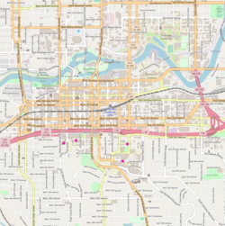
The Peaceful Valley Historic District is a National Register of Historic Places-listed historic district in the Peaceful Valley neighborhood of Spokane, Washington. It is located in the western half of the neighborhood, along the floor and southern slope of the Spokane River Gorge, immediately south of the Spokane River and downhill, just below Downtown Spokane. It is centered on the intersection of Main Avenue and Maple Street, stretching from there approximately two blocks in each direction.[2]
A residential area, Peaceful Valley was one of the first areas developed in the City of Spokane and was deemed historically significant as an intact example of a working-class neighborhood from the turn of the 20th century. Unlike many other historic districts around the city and state, Peaceful Valley does not represent the moneyed-elite whose grand homes and buildings have been preserved but rather homes of the working class laborers who helped built Spokane throughout its early decades.[2]
Located in a steep valley just downstream of Spokane Falls and immediately below the city center which lies on the flat land at the top of the valley to the south and east. This location, isolated by the river and deep gorge, have helped preserve Peaceful Valley's architectural character into the 21st century, though some construction projects such as the Maple Street Bridge which was constructed over the area in the late 1950s have slightly altered the appearance in places, though not the overall cohesion, of the district.[2]
- ^ "NPGallery Asset Detail". nps.gov. National Park Service. Retrieved April 16, 2024.
- ^ a b c "National Register of Historic Places Inventory — Nomination Form" (PDF). historicspokane.org. National Park Service. Retrieved April 16, 2024.


