Peach Springs, Arizona
Walapai: Hàkđugwi:v | |
|---|---|
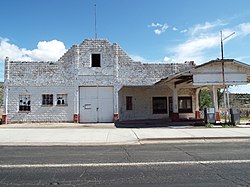
 John Osterman Shell gas station | |
 Location in Mohave County and the state of Arizona | |
| Coordinates: 35°32′4″N 113°25′24″W / 35.53444°N 113.42333°W | |
| Country | United States |
| State | Arizona |
| County | Mohave |
| Area | |
• Total | 7.91 sq mi (20.50 km2) |
| • Land | 7.91 sq mi (20.50 km2) |
| • Water | 0.00 sq mi (0.00 km2) |
| Elevation | 4,780 ft (1,457 m) |
| Population | |
• Total | 1,098 |
| • Density | 138.74/sq mi (53.57/km2) |
| Time zone | UTC-7 (MST) |
| • Summer (DST) | UTC−7 (no DST[3]) |
| ZIP code | 86434 |
| Area code | 928 |
| FIPS code | 04-53770 |
| GNIS feature ID | 9278 |
Peach Springs (Walapai: Hàkđugwi:v[4]) is a census-designated place (CDP) in Mohave County, Arizona, United States. The population was 1,098 at the 2020 census.[2] Peach Springs serves as the administrative headquarters of the Hualapai people and is located on the Hualapai Reservation.
- ^ "2021 U.S. Gazetteer Files: Arizona". United States Census Bureau. Retrieved May 25, 2022.
- ^ a b "P1. Race – Peach Springs CDP, Arizona: 2020 DEC Redistricting Data (PL 94-171)". U.S. Census Bureau. Retrieved May 25, 2022.
- ^ "Peach Springs, Arizona Local Time Details". Retrieved June 19, 2019.
- ^ Watahomigie, Lucille, Jorigine Bender, Akira Yamamoto, University of Los Angeles. Hualapai reference grammar. 1982.


