| Pecatonica River | |
|---|---|
 The Pecatonica River in the Pecatonica River Woods State Natural Area in Iowa County, Wisconsin | |
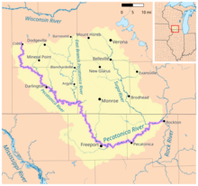
 Map of the Pecatonica River watershed | |
| Physical characteristics | |
| Source | |
| • location | Iowa County northwest of Cobb, Wisconsin |
| • coordinates | 42°58′44″N 90°20′37″W / 42.9788889°N 90.3436111°W |
| • elevation | 1,188 ft (362 m) |
| Mouth | |
• location | Confluence with the Rock River at Rockton, Illinois |
• coordinates | 42°27′00″N 89°04′30″W / 42.45°N 89.075°W |
• elevation | 712 ft (217 m) |
| Length | 194 mi (312 km) |
| Discharge | |
| • location | Shirland, Illinois |
| • average | 2,011 cu/ft. per sec.[1] |
| Basin features | |
| Progression | Pecatonica River → Rock → Mississippi → Gulf of Mexico |
| GNIS ID | 415503 |
The Pecatonica River is a tributary of the Rock River, 194 miles (312 km) long,[2] in southern Wisconsin and northern Illinois in the United States.
The word Pecatonica is an anglicization of two Algonquian language words: Bekaa (or Pekaa in some dialects), which means "slow", and niba, which means "water", forming the conjunction Bekaaniba or "Slow Water".
It rises in the hills of southwest Wisconsin, in southwest Iowa County, 2 miles (3 km) west of Cobb. It flows south, then southeast, past Calamine and Darlington. In southeast Lafayette County it receives the East Branch Pecatonica River, approximately 8 miles (13 km) north of the state line. It flows south-southeast into Illinois, past Freeport, where it turns east, then east-northeast, receiving the Sugar River near Shirland in northern Winnebago County, 5 miles (8 km) south of the state line. It joins the Rock at Rockton, approximately 15 miles (24 km) north of Rockford.
- ^ "USGS Current Conditions for USGS 05437050 PECATONICA RIVER NR SHIRLAND, ILL".
- ^ U.S. Geological Survey. National Hydrography Dataset high-resolution flowline data. The National Map, accessed May 13, 2011