| Pedernales River | |
|---|---|
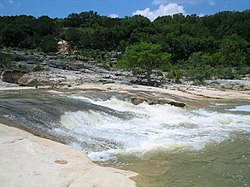
 The Pedernales River in Pedernales Falls State Park | |
 Location of Pedernales River, Texas | |
| Location | |
| Country | United States |
| State | Texas |
| Region | Edwards Plateau, Texas Hill Country |
| Physical characteristics | |
| Source | Kerr County, Texas |
| • coordinates | 30°15′45″N 99°19′31″W / 30.26250°N 99.32528°W |
| • elevation | 690 m (2,260 ft)[1] |
| Mouth | Lake Travis, Travis County, Texas |
• coordinates | 30°25′51″N 98°03′36″W / 30.43083°N 98.06000°W |
• elevation | 197 m (646 ft)[2] |
| Length | 170 km (110 mi) |
| Basin size | 3,297 km2 (1,273 sq mi) |
| Discharge | |
| • average | 2.3 m3/s (81 cu ft/s) |
The Pedernales River (/ˌpɜːrdəˈnælɪs/ PUR-də-NAL-iss) is a tributary of the Colorado River, approximately 106 miles (171 km) long, in Central Texas in the United States.[2] It drains an area of the Edwards Plateau, flowing west to east across the Texas Hill Country west of Austin. The name "Pedernales", first used in the middle 18th century, comes from a Spanish word for the flint rocks characteristic of the riverbed.
- ^ Cite error: The named reference
USGSwas invoked but never defined (see the help page). - ^ a b "Pedernales River". Geographic Names Information System. United States Geological Survey, United States Department of the Interior. Retrieved 2019-08-12.