| Peel River Cockburn River[1] | |
|---|---|
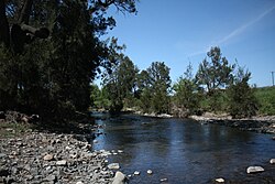
 Peel River at Nundle | |
 | |
| Etymology | in honour of Sir Robert Peel[2] |
| Location | |
| Country | Australia |
| State | New South Wales |
| Region | IBRA: New England Tablelands |
| District | Northern Tablelands |
| Municipalities | Tamworth, Gunnedah |
| Physical characteristics | |
| Source | Liverpool Range, Great Dividing Range, and Mount Royal Range |
| • location | south of Nundle |
| • elevation | 743 m (2,438 ft) |
| Mouth | confluence with the Namoi River |
• location | south of Keepit Dam |
• elevation | 286 m (938 ft) |
| Length | 210 km (130 mi) |
| Basin features | |
| River system | Murray–Darling basin |
| Tributaries | |
| • right | Cockburn River |
| Bridges | Peel River railway bridge, Tamworth |
| Reservoir | Chaffey Dam |
| [3] | |
Peel River, a watercourse that is part of the Namoi catchment within the Murray–Darling basin, is located in the North West Slopes and Plains district of New South Wales, Australia.
- ^ "Peel River (A Section Of)". Geographical Names Register (GNR) of NSW. Geographical Names Board of New South Wales. Retrieved 19 January 2013.
- ^ "Peel River". Geographical Names Register (GNR) of NSW. Geographical Names Board of New South Wales. Retrieved 19 January 2013.
- ^ "Map of Peel River". Bonzle.com. Retrieved 19 January 2013.