| Pejar Dam | |
|---|---|
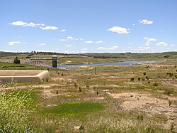
 Pejar Dam in November 2005 | |
Location of the Pejar Dam in New South Wales | |
| Country | Australia |
| Location | Southern Tablelands, New South Wales |
| Coordinates | 34°34′54″S 149°34′33″E / 34.58167°S 149.57583°E |
| Purpose | Potable water supply |
| Status | Operational |
| Opening date | 1979 |
| Owner(s) | Goulburn Mulwaree Council |
| Dam and spillways | |
| Type of dam | Embankment dam |
| Impounds | Wollondilly River |
| Height | 26 m (85 ft) |
| Length | 367 m (1,204 ft) |
| Dam volume | 95×103 m3 (3.4×10⁶ cu ft) |
| Spillway type | Uncontrolled |
| Spillway capacity | 2,470 m3/s (87,000 cu ft/s) |
| Reservoir | |
| Total capacity | 9,000 ML (320×106 cu ft) |
| Catchment area | 143 km2 (55 sq mi) |
| Surface area | 1.55 km2 (0.60 sq mi) |

The Pejar Dam is an earth and rock-filled embankment dam with an uncontrolled spillway across the Wollondilly River, located in the Southern Tablelands region of New South Wales, Australia. The principal purpose of the dam is to supply potable water for the city of Goulburn. The impounded 9,000-megalitre (320×106 cu ft) reservoir is also called Pejar Dam.
