Pembamnazi
Kata ya Pembamnazi (Swahili) | |
|---|---|
|
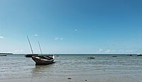
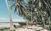
From top to bottom: Scene at Pembamnazi ward, Boat at Buyuni town in Pembamnazi ward, Buyuni beach at Pembamnazi | |
| Nickname: The gem of Kigamboni | |
 | |
| Coordinates: 7°5′49.92″S 39°26′10.32″E / 7.0972000°S 39.4362000°E | |
| Country | |
| Region | Dar es Salaam Region |
| District | Kigamboni District |
| Headquarters | Buyuni |
| Area | |
| • Total | 209 km2 (81 sq mi) |
| Population (2012) | |
| • Total | 9,672 |
| Ethnic groups | |
| • Settler | Swahili |
| • Ancestral | Zaramo |
| Tanzanian Postal Code | 17105 |
Pembamnazi, also known as Pemba Mnazi, (Kata ya Pembamnazi, in Swahili) is an administrative ward in the Kigamboni district of Dar es Salaam Region in Tanzania. The Indian Ocean forms the ward's eastern and southern boundaries. The Pwani Region's Mkuranga District's Shungubweni and Vianzi Wards are to the west. The ward is bordered to the north by the wards of Kisarawe II and Kimbiji. In 2016 the Tanzania National Bureau of Statistics report there were 12,112 people in the ward, from 9,672 in 2012.[1][2]
- ^ 2012 Population and Housing Census - Population Distribution by Administrative Areas (PDF) (Report). Dar es Salaam, Tanzania: National Bureau of Statistics. 1 March 2013. Archived (PDF) from the original on 26 March 2022. Retrieved 3 July 2022.
- ^ 2016 Makadirio ya Idadi ya Watu katika Majimbo ya Uchaguzi kwa Mwaka 2016, Tanzania Bara [Population Estimates in Administrative Areas for the Year 2016, Mainland Tanzania] (PDF) (Report) (in Swahili). Dar es Salaam, Tanzania: National Bureau of Statistics. 1 April 2016. Archived (PDF) from the original on 27 December 2021. Retrieved 3 July 2022.


