| Pembridge | |
|---|---|
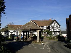
 Market Place, with the open-sided Market Hall in the foreground and the New Inn beyond | |
Location within Herefordshire | |
| Population | 1,056 (2011 Census) |
| OS grid reference | SO 391 581 |
| Civil parish |
|
| Unitary authority | |
| Ceremonial county | |
| Region | |
| Country | England |
| Sovereign state | United Kingdom |
| Post town | Leominster |
| Postcode district | HR6 |
| Dialling code | 01544 |
| Police | West Mercia |
| Fire | Hereford and Worcester |
| Ambulance | West Midlands |
| UK Parliament | |
| Website | Pembridge Parish Council |
Pembridge is a village and civil parish in the Arrow valley in Herefordshire, England. The village is on the A44 road about 6 miles (10 km) east of Kington and 7 miles (11 km) west of Leominster. The civil parish includes the hamlets of Bearwood, Lower Bearwood, Lower Broxwood, Marston, Moorcot and Weston. The 2011 Census recorded the parish population as 1,056.[1]
Pembridge is the major part of the electoral ward of Pembridge and Lyonshall with Titley. The 2011 Census recorded the ward's population as 3,124.[2]
- ^ "Area: Pembridge (Parish): Key Figures for 2011 Census: Key Statistics". Neighbourhood Statistics. Office for National Statistics. Retrieved 29 December 2015.
- ^ "Area: Pembridge and Lyonshall with Titley (Ward): Key Figures for 2011 Census: Key Statistics". Neighbourhood Statistics. Office for National Statistics. Retrieved 29 December 2015.
