Penghu Islands
澎湖縣 Pescadores | |
|---|---|
| Penghu County | |
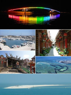
 Clockwise from the top: A night view of Xiying Rainbow Bridge, Zhongyang Old Street, Qimei Double-Heart of Stacked Stones, Baisha Beach, Penghu Tianhou Temple, Budai Harbor | |
 | |
 | |
| Coordinates: 23°34′03″N 119°34′39″E / 23.56750°N 119.57750°E | |
| Country | |
| Province | Taiwan Province (streamlined) |
| Seat | Magong City |
| Largest city | Magong |
| Boroughs | One city, five rural townships |
| Government | |
| • Body | |
| • County Magistrate | Chen Kuang-fu (DPP) |
| Area | |
• Total | 141.052 km2 (54.460 sq mi) |
| • Rank | 22 of 22 |
| Population (December 2014) | |
• Total | 101,758 |
| • Rank | 21 of 22 |
| • Density | 720/km2 (1,900/sq mi) |
| Time zone | UTC+8 (National Standard Time) |
| ISO 3166 code | TW-PEN |
| Website | www.penghu.gov.tw |
| Symbols | |
| Bird | Small Skylark (Alauda gulgula) |
| Flower | Firewheel (Gaillardia pulchella) |
| Tree | Chinese Banyan (Ficus microcarpa) |
| Penghu Islands | |||||||||||||||||||||||||||||||
|---|---|---|---|---|---|---|---|---|---|---|---|---|---|---|---|---|---|---|---|---|---|---|---|---|---|---|---|---|---|---|---|
| Traditional Chinese | 澎湖群島 | ||||||||||||||||||||||||||||||
| Postal | Pescadores Islands | ||||||||||||||||||||||||||||||
| |||||||||||||||||||||||||||||||
| Penghu Island | |||||||||||||||||||||||||||||||
| Traditional Chinese | 澎湖島 | ||||||||||||||||||||||||||||||
| |||||||||||||||||||||||||||||||
| Penghu County | |||||||||||||||||||||||||||||||
| Traditional Chinese | 澎湖縣 | ||||||||||||||||||||||||||||||
| |||||||||||||||||||||||||||||||
Song dynasty (1170–1279)
Great Yuan Empire (1281–1368)
Great Ming Empire (1368–1622, 1624–1644)Dutch Empire (1622–1624)
Kingdom of Tungning (1661–1683)
Great Qing Empire (1683–1895)
Empire of Japan (1895–1945)
Republic of China (1945–present)

The Penghu (/ˈpʌŋˈhuː/ PUNG-HOO,[1] Hokkien POJ: Phîⁿ-ô͘ or Phêⁿ-ô͘ ) or Pescadores Islands are an archipelago of 90 islands and islets in the Taiwan Strait, located approximately 50 km (31 mi) west of the main island of Taiwan across the Penghu Channel, covering an area of 141 square kilometers (54 sq mi). The archipelago collectively forms Penghu County of Taiwan and is the smallest county of Taiwan. The largest city is Magong, located on the largest island, which is also named Magong.
The Penghu islands first appear in the historical record during the Tang dynasty and were inhabited by Chinese people under the Southern Song dynasty, during which they were attached to Jinjiang County of Fujian.[2] The archipelago was formally incorporated as an administrative unit of China in 1281 under Tong'an County of Jiangzhe Province during the Yuan dynasty.[3] It continued to be controlled by Imperial China with brief European occupations by the Dutch Empire (1622–1624) and Second French colonial empire (1885), until it was ceded to the Japanese Empire in 1895. Since the end of World War II, Penghu has been governed by the Republic of China (ROC). Under the terms of the Sino-American Mutual Defense Treaty and the subsequent Taiwan Relations Act between the ROC and the United States, Penghu is defined and geographically acknowledged as part of Taiwan.[4][5]
Penghu Islands rely solely on sea and air transportation, with air transport having a significant role in outside access. The islands are served by three local domestic airports: Penghu Airport, Qimei Airport, and Wang-an Airport. The Penghu National Scenic Area comprises most of the islands and islets of the archipelago. It is also renowned for its unique natural feature of columnar basalt landscape. Tourism is one of the main sources of income to the county.
- ^ "Penghu". Merriam-Webster.com Dictionary. Merriam-Webster.
- ^ Liu 2012, p. 167-168.
- ^ Cite error: The named reference
官網歷史沿革was invoked but never defined (see the help page). - ^ "Taiwan Relations Act". ait.org.tw. American Institute in Taiwan. 30 March 2022. Archived from the original on 19 August 2022. Retrieved 14 December 2022.
...Section. 15. For purposes of this Act- 2. the term "Taiwan" includes, as the context may require, the islands of Taiwan and the Pescadores (Penghu).
- ^ "Sino-American Mutual Defense Treaty". ait.org.tw. American Institute in Taiwan. 1954. Archived from the original on 24 December 2022. Retrieved 14 December 2022.
ARTICLE VI. For the purposes of Articles II and V, the terms "territorial" and "territories" shall mean in respect of the Republic of China, Taiwan and the Pescadores: and in respect of the United States of America, the island territories in the West Pacific under its jurisdiction.

