Pennant Hills Road Cumberland Highway | |
|---|---|
 | |
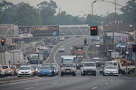
| Pennant Hills Road at Thornleigh in 2016 | |
| Coordinates |
|
| General information | |
| Type | Highway |
| Length | 16.1 km (10 mi)[3] |
| Gazetted | August 1928 (as Main Road 13)[1] August 1988 (as State Highway 13, Cumberland Highway)[2] |
| Route number(s) | (Wahroonga–North Parramatta) |
| Former route number |
|
| Major junctions | |
| Northeast end | Wahroonga, Sydney |
| |
| Southwest end | Church Street Parramatta, Sydney |
| Location(s) | |
| Major suburbs | Normanhurst, Thornleigh, Pennant Hills, Carlingford |
| Highway system | |
| ---- | |
Pennant Hills Road is a 16.1-kilometre-long (10.0 mi)[3] arterial road located in Sydney, New South Wales, Australia. The road links the suburb of Wahroonga in the northeast, to the major central business district of Parramatta in the southwest. Apart from a small section at its southwestern end, it is a constituent part of Cumberland Highway, and is designated part of route A28.
In 2015 NRMA members voted the Pennant Hills Road as the second worst road in New South Wales and the Australian Capital Territory, with approximately 5,000 heavy vehicle movements per day.[4] NorthConnex, a 9-kilometre (5.6 mi) motorway tunnel opened on 31 October 2020, runs parallel to Pennant Hills Road and links M2 Hills Motorway at West Pennant Hills with Pacific Highway and Pacific Motorway at Wahroonga. NorthConnex aims to reduce congestion and improve traffic flow along part of the Pennant Hills Road, reducing air and traffic pollution.[5]
- ^ "Main Roads Act, 1924-1927". Government Gazette of the State of New South Wales. No. 110. National Library of Australia. 17 August 1928. pp. 3814–20. Archived from the original on 3 August 2022. Retrieved 1 August 2022.
- ^ "State Roads Act". Government Gazette of the State of New South Wales. No. 138. National Library of Australia. 26 August 1988. p. 4505. Archived from the original on 16 January 2023. Retrieved 16 January 2023.
- ^ a b "Pennant Hills Road" (Map). Google Maps. Retrieved 26 August 2022.
- ^ Vaughan, Craig (28 October 2015). "Pennant Hills Rd was voted the second worst road in NSW and the ACT in the NRMA's annual survey". Hornsby Advocate. Retrieved 23 October 2016.
- ^ "Frequently asked questions - NorthConnex". www.northconnex.com.au. Retrieved 9 October 2020.
