Pennfield | |
|---|---|
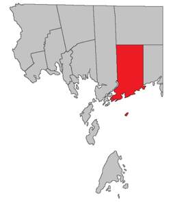
 Location within Charlotte County. | |
| Country | |
| Province | |
| County | Charlotte County |
| Erected | 1786 |
| Area | |
| • Land | 363.75 km2 (140.44 sq mi) |
| Population (2021)[1] | |
| • Total | 2,222 |
| • Density | 6.1/km2 (16/sq mi) |
| • Change 2016-2021 | |
| • Dwellings | 1,029 |
| Time zone | UTC-4 (AST) |
| • Summer (DST) | UTC-3 (ADT) |
| Figures do not include portion within the village of Blacks Harbour | |
Pennfield is a geographic parish in Charlotte County, New Brunswick, Canada,[4] located west of Saint John located east of St. George and west of Saint John.
For governance purposes, Utopia and areas south of Route 780 are part of the incorporated rural community of Eastern Charlotte,[5] while the sparsely populated north and The Wolves islands in the Bay of Fundy are part of the Southwest rural district,[6] both of which are members of the Southwest New Brunswick Service Commission.[7]
Prior to the 2023 governance reform, it comprised one village of Blacks Harbour and two local service districts, all of which were members of the Southwest New Brunswick Service Commission (SNBSC).[8]
The Census subdivision of the same name includes all of the parish except the former village of Blacks Harbour.[1]
- ^ a b c "Census Profile". Statistics Canada. 26 October 2022. Retrieved 30 October 2022.
- ^ "Chapter T-3 Territorial Division Act". Government of New Brunswick. Retrieved 5 June 2023.
- ^ "Chapter I-13 Interpretation Act". Government of New Brunswick. Retrieved 5 June 2023.
- ^ The Territorial Division Act[2] divides the province into 152 parishes, the cities of Saint John and Fredericton, and one town of Grand Falls. The Interpretation Act[3] clarifies that parishes include any local government within their borders.
- ^ "Southwest Regional Service Commission: RSC 10". Government of New Brunswick. Retrieved 5 June 2023.
- ^ "Southwest Regional Service Commission: RD 10". Government of New Brunswick. Retrieved 5 June 2023.
- ^ "Regions Regulation – Regional Service Delivery Act". Government of New Brunswick. 21 July 2022. Retrieved 5 June 2023.
- ^ "Communities in each of the 12 Regional Service Commissions (RSC) / Les communautés dans chacune des 12 Commissions de services régionaux (CSR)" (PDF), Government of New Brunswick, July 2017, retrieved 1 February 2021