Borough of Pennsburg | |
|---|---|
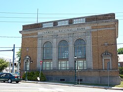
 Farmers National Bank Building, built in 1926 in Pennsburg, in May 2015 | |
 Location of Pennsburg in Montgomery County, Pennsylvania | |
Location of Pennsburg in Pennsylvania | |
| Coordinates: 40°23′44″N 75°29′50″W / 40.39556°N 75.49722°W | |
| Country | United States |
| State | Pennsylvania |
| County | Montgomery |
| Incorporated | April 9, 1888 |
| Government | |
| • Type | Council-manager |
| • Mayor | Vicki J. Lightcap |
| Area | |
• Total | 0.80 sq mi (2.07 km2) |
| • Land | 0.80 sq mi (2.07 km2) |
| • Water | 0.00 sq mi (0.00 km2) |
| Elevation | 381 ft (116 m) |
| Population | |
• Total | 3,889 |
| • Density | 4,861.25/sq mi (1,876.24/km2) |
| Time zone | UTC-5 (EST) |
| • Summer (DST) | UTC-4 (EDT) |
| ZIP Code | 18073 |
| Area codes | 215, 267, and 445 |
| FIPS code | 42-59120 |
| School district | Upper Perkiomen School District |
| Website | http://www.pennsburg.us |
Pennsburg is a borough in Montgomery County, Pennsylvania. Its population was 3,889 at the 2020 census. It is part of the Upper Perkiomen School District. It is also part of the strip of small towns that run together along Route 29: Red Hill, Pennsburg, and East Greenville. The towns are collectively referred to as Upper Perk.
- ^ "ArcGIS REST Services Directory". United States Census Bureau. Retrieved October 12, 2022.
- ^ Cite error: The named reference
USCensusDecennial2020CenPopScriptOnlywas invoked but never defined (see the help page).

