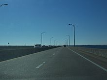
Pensacola Bay Bridge | |
|---|---|
 The current bridge, looking northeast | |
| Coordinates | 30°23′46″N 87°11′08″W / 30.395983°N 87.185644°W |
| Carries | 6 lanes of |
| Crosses | Pensacola Bay |
| Locale | Pensacola, Florida, and Gulf Breeze, Florida, U.S. |
| Official name | Philip Dane Beall Sr., Memorial Bridge (Previous Bridge) Gen. Daniel "Chappie" James Jr. Bridge (Both Eastbound and Westbound bridges of new project) |
| Maintained by | Florida Department of Transportation (FDOT) |
| ID number | 480035 |
| Website | pensacolabaybridge |
| Characteristics | |
| Design | Reinforced concrete girder bridge |
| Total length | 16,140 feet (4,920 meters) |
| Width | 55 feet (17 meters) |
| Longest span | 377 feet (115 meters) |
| Clearance below | 65 feet (20 meters) |
| History | |
| Opened | June 13, 1931 (original bridge) October 31, 1960 (second bridge) September 5, 2019 (current bridge, eastbound span) February 14, 2023 (current bridge, westbound span) [1] |
| Statistics | |
| Daily traffic | 485,864,334 [2] |
| Location | |
 | |

The Pensacola Bay Bridge, also known locally as the Three-Mile Bridge, runs between downtown Pensacola, Florida, and Gulf Breeze, Florida. It carries six lanes of U.S. Highway 98 across Pensacola Bay.
- ^ "Westbound span of Pensacola Bay Bridge is open. PPD has already made 21 traffic stops".
- ^ FDOT Florida Traffic Online Archived July 28, 2013, at the Wayback Machine Accessed May 25, 2011.