| Penwith District | |
|---|---|
 | |
| Population | |
| • 1973 | 51,690[1] |
| • 2001 | 62,994[2] |
| History | |
| • Origin |
|
| • Created | 1 April 1974 |
| • Abolished | 1 April 2009 |
| • Succeeded by | Cornwall unitary authority |
| Status | Former district |
| ONS code | 15UF |
| Government | District council |
| • HQ | Penzance |
| • Motto | Kensa ha Dewetha |
| Subdivisions | |
| • Type | Civil parishes |
 | |


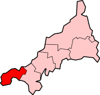
Penwith (/ˌpɛnˈwɪθ/; Cornish: Pennwydh) is an area of Cornwall, England, located on the peninsula of the same name. It is also the name of a former local government district, whose council was based in Penzance. The area is named after one of the ancient administrative hundreds of Cornwall which derives from two Cornish words, penn meaning 'headland' and wydh meaning 'at the end'.
Natural England have designated the peninsula as national character area 156 and named it West Penwith. It is also known as the Land's End Peninsula.[3]
- ^ Local government in England and Wales: A Guide to the New System. London: HMSO. 1974. p. 38. ISBN 0-11-750847-0.
- ^ "Census 2001: Penwith". Census 2001. Office for National Statistics. 1 April 2001. Retrieved 5 January 2009.
- ^ NCA Profile:156 West Penwith (NE371) at publications.naturalengland.org.uk. Accessed on 8 September 2013