Perkinsville, Vermont | |
|---|---|
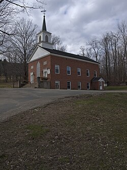
 Perkinsville Community Church | |
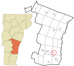
 Location in Windsor County and the state of Vermont. | |
| Coordinates: 43°22′21″N 72°30′56″W / 43.37250°N 72.51556°W | |
| Country | United States |
| State | Vermont |
| County | Windsor |
| Area | |
• Total | 0.19 sq mi (0.49 km2) |
| • Land | 0.18 sq mi (0.47 km2) |
| • Water | 0.01 sq mi (0.02 km2) |
| Elevation | 561 ft (171 m) |
| Population (2020) | |
• Total | 108 |
| • Density | 570/sq mi (220/km2) |
| Time zone | UTC−5 (Eastern (EST)) |
| • Summer (DST) | UTC−4 (EDT) |
| ZIP Code | 05151 |
| Area code | 802 |
| FIPS code | 50-54850[2] |
| GNIS feature ID | 1458942[3] |
Perkinsville was a village located in the town of Weathersfield, Windsor County, Vermont, United States. The population was 108 at the 2020 census.[4]
The village government was dissolved in 2020;[5] the town of Weathersfield is now responsible for general governance, including village streetlights.
- ^ "2019 U.S. Gazetteer Files". United States Census Bureau. Retrieved August 7, 2020.
- ^ "U.S. Census website". United States Census Bureau. Retrieved January 31, 2008.
- ^ "US Board on Geographic Names". United States Geological Survey. October 25, 2007. Retrieved January 31, 2008.
- ^ "Census - Geography Profile: Perkinsville village, Vermont". United States Census Bureau. Retrieved December 26, 2021.
- ^ "Boundary and Annexation Survey (BAS) New Incorporations, Mergers, Consolidations, and Disincorporations".