Perloja | |
|---|---|
Village | |
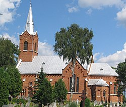
 Perloja's church | |
| Coordinates: 54°12′52″N 24°24′52″E / 54.21444°N 24.41444°E | |
| Country | |
| Ethnographic region | Dzūkija |
| County | |
| Municipality | Varėna district municipality |
| Eldership | Varėna eldership |
| First mentioned | 1378 |
| Granted Magdeburg rights | 1792 |
| Population (2021) | |
| • Total | 484 |
| Time zone | UTC+2 (EET) |
| • Summer (DST) | UTC+3 (EEST) |
Perloja is a village in Varėna district, Lithuania. It is situated 19 km (12 mi) to the west from Varėna on the banks of Merkys River and on the Vilnius–Druskininkai road. According to the 2001 census, it had 774 inhabitants.[1] The village is known for the so-called Republic of Perloja, an independent, albeit unrecognised microstate that was established in the aftermath of World War I and existed until 1923.[2]


