Perry Hall, Maryland | |
|---|---|
 Perry Hall High School in Perry Hall, Maryland | |
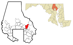
 Location of Perry Hall, Maryland | |
| Coordinates: 39°24′5″N 76°28′44″W / 39.40139°N 76.47889°W | |
| Country | |
| State | |
| County | |
| Named for | Perry Hall Mansion |
| Area | |
• Total | 6.94 sq mi (17.97 km2) |
| • Land | 6.94 sq mi (17.97 km2) |
| • Water | 0.00 sq mi (0.01 km2) |
| Elevation | 253 ft (77 m) |
| Population (2020) | |
• Total | 29,409 |
| • Density | 4,239.44/sq mi (1,636.79/km2) |
| Time zone | UTC−5 (Eastern (EST)) |
| • Summer (DST) | UTC−4 (EDT) |
| ZIP codes | 21128, 21234, 21236 [2] |
| Area code | 410 |
| FIPS code | 24-60975 |
| GNIS feature ID | 0590995 |
Perry Hall is an unincorporated community and census-designated place in Baltimore County, Maryland, United States. The population was 28,474 at the 2010 census.[3] It is a suburb of Baltimore.
- ^ "2020 U.S. Gazetteer Files". United States Census Bureau. Retrieved April 26, 2022.
- ^ "Perry Hall Maryland ZIP Codes - Map and Full List". ZipDataMaps.
- ^ "Profile of General Population and Housing Characteristics: 2010 Demographic Profile Data (DP-1): Perry Hall CDP, Maryland". United States Census Bureau. Retrieved February 29, 2012.