You can help expand this article with text translated from the corresponding article in Spanish. Click [show] for important translation instructions.
|
10°29′N 66°49′W / 10.483°N 66.817°W
Dulce Nombre de Jesús de Petare | |
|---|---|
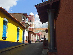
 Historic center of Petare | |
| Coordinates: 10°29′N 66°49′W / 10.483°N 66.817°W | |
| Country | |
| State | Miranda |
| Founded | February 17, 1621 |
| Government | |
| • Mayor | Carlos Ocariz |
| • Political party | Justice First |
| Elevation | 900 m (3,000 ft) |
| Population (2006) | |
• Total | 369,000 |
| Demonym | Petareño(a) |
| Time zone | UTC−4 (VET) |
| Postal code | 1073 |
| Website | alcaldiamunicipiosucre.gov.ve |

Dulce Nombre de Jesús de Petare is a neighborhood in Miranda, Venezuela, and is part of the Metropolitan District of Caracas. It is located in the Sucre Municipality, one of the five divisions of Caracas. The city was founded in 1621 under the name of San Jose de Guanarito. It grew to become a part of the Greater Caracas area as the latter expanded in area and population. Petare had a population of 372,106 inhabitants and about 448,861 according to 2020 estimates.[1] Petare is the biggest slum in Venezuela, and in South America.
The neighborhood is towards the eastern edge of Caracas, but has developed its own commercial core. Two universities are located in Petare: Universidad Santa María and Universidad Metropolitana. Poverty remains a major limitation to the city's development.
- ^ "Archived copy". Archived from the original on December 8, 2022. Retrieved November 4, 2022.
{{cite web}}: CS1 maint: archived copy as title (link)


