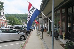
Peterborough, New Hampshire | |
|---|---|
 Main Street | |
| Coordinates: 42°52′36″N 71°57′2″W / 42.87667°N 71.95056°W | |
| Country | United States |
| State | New Hampshire |
| County | Hillsborough |
| Town | Peterborough |
| Area | |
• Total | 4.79 sq mi (12.41 km2) |
| • Land | 4.77 sq mi (12.35 km2) |
| • Water | 0.03 sq mi (0.06 km2) |
| Elevation | 730 ft (220 m) |
| Population (2020) | |
• Total | 3,090 |
| • Density | 648.21/sq mi (250.25/km2) |
| Time zone | UTC-5 (Eastern (EST)) |
| • Summer (DST) | UTC-4 (EDT) |
| ZIP code | 03458 |
| Area code | 603 |
| FIPS code | 33-60500 |
| GNIS feature ID | 2378086 |
Peterborough is a census-designated place (CDP) and the main village in the town of Peterborough, Hillsborough County, New Hampshire, United States. The population of the CDP was 3,090 at the 2020 census,[2] out of 6,418 in the entire town.
- ^ "ArcGIS REST Services Directory". United States Census Bureau. Retrieved September 20, 2022.
- ^ "Peterborough CDP, New Hampshire: 2020 DEC Redistricting Data (PL 94-171)". U.S. Census Bureau. Retrieved December 10, 2021.

