| Petroglyphs Provincial Park | |
|---|---|
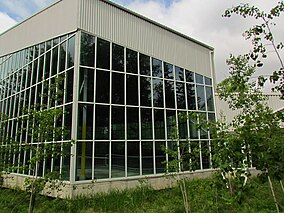
 Building protecting petroglyphs | |
Location of the park in Southern Ontario | |
| Location | Woodview, Ontario, Canada |
| Nearest city | Peterborough |
| Coordinates | 44°36′55″N 78°02′27″W / 44.615225°N 78.04076°W |
| Area | 16.43 km2 (6.34 sq mi) |
| Established | 1976 |
| Visitors | 17,735 (in 2022[2]) |
| Governing body | Ontario Parks |
| Website | https://www.ontarioparks.ca/park/petroglyphs |
 | |
| Official name | Peterborough Petroglyphs National Historic Site of Canada |
| Designated | 1981 |
Petroglyphs Provincial Park is a historical-class provincial park situated in Woodview, Ontario, Canada, northeast of Peterborough. It has the largest collection of ancient First Nations petroglyphs (rock carvings) in Ontario. The carvings were created in the pre-Columbian era and represents aspects of First Nations spirituality, including images of shamans, animals, reptiles, and, possibly, the Great Spirit itself.
The location of the site was kept hidden from non-First Nation people until 1954, when it was rediscovered accidentally by a prospector (Everett Davis)[3] of the Industrial Minerals of Canada. The immediate area of the petroglyphs has been designated a National Historic Site of Canada.[4]
- ^ UNEP-WCMC. "Protected Area Profile for Petroglyphs Provincial Park". World Database on Protected Areas. Retrieved 2024-11-08.
- ^ Parks, Ontario. "Ontario_Parks-Visitation-Statistics 2022 - Ministries". data.ontario.ca. Retrieved 2024-11-08.
- ^ The Milwaukee Journal - Oct 27, 1962, google news
- ^ Peterborough Petroglyphs. Canadian Register of Historic Places.
