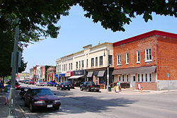
Petrolia | |
|---|---|
| Town of Petrolia | |
 | |
| Nickname: Canada's Victorian Oil Town | |
| Coordinates: 42°53′N 82°08.5′W / 42.883°N 82.1417°W | |
| Country | |
| Province | |
| County | Lambton |
| Settled | 1866 |
| Incorporated | 25 December 1866 |
| Government | |
| • Mayor | Brad Loosley |
| • Federal riding | Sarnia—Lambton |
| • Prov. riding | Sarnia—Lambton |
| Area | |
| • Land | 12.68 km2 (4.90 sq mi) |
| Population (2016)[1] | |
| • Total | 5,742 |
| • Density | 452.8/km2 (1,173/sq mi) |
| Time zone | UTC-5 (Eastern (EST)) |
| • Summer (DST) | UTC-4 (EDT) |
| Postal code | N0N 1R0 |
| Area code(s) | 519 and 226 |
| Website | town.petrolia.on.ca |
Petrolia is a town in southwestern Ontario, Canada. It is part of Lambton County and is surrounded by Enniskillen Township. It is billed as "Canada's Victorian Oil Town" and is often credited with starting the oil industry in North America, a claim shared with the nearby town of Oil Springs.[2]
Lambton Central Collegiate & Vocational Institute (LCCVI) is located in Petrolia.
- ^ a b "Petrolia census profile". 2016 Census of Population. Statistics Canada. 8 February 2017. Retrieved 18 March 2017.
- ^ "Oil Springs". Oil Museum of Canada. Archived from the original on 7 August 2008.

