Petroupoli
Πετρούπολη | |
|---|---|
 | |
| Coordinates: 38°2′N 23°41′E / 38.033°N 23.683°E | |
| Country | Greece |
| Administrative region | Attica |
| Regional unit | West Athens |
| Government | |
| • Mayor | Evangelos Simos[1] (since 2023) |
| Area | |
| • Municipality | 6.597 km2 (2.547 sq mi) |
| Highest elevation | 262 m (860 ft) |
| Lowest elevation | 108 m (354 ft) |
| Population (2021)[2] | |
| • Municipality | 60,146 |
| • Density | 9,100/km2 (24,000/sq mi) |
| Time zone | UTC+2 (EET) |
| • Summer (DST) | UTC+3 (EEST) |
| Postal code | 13231 |
| Area code(s) | 210 50 |
| Vehicle registration | ΙΖΧ |
| Website | www.petroupoli.gov.gr |
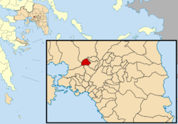
Petroupoli (Greek: Πετρούπολη, meaning "City/town of Petros/Peter") is a semi-mountainous town in Attica, in the west suburbs of Athens. Petroupoli was part of the community of Nea Liosia until 1946, when it became a separate community. It was elevated to municipality status in 1972.[3]
- ^ Municipality of Petroupoli, Municipal elections – October 2023, Ministry of Interior
- ^ "Αποτελέσματα Απογραφής Πληθυσμού - Κατοικιών 2021, Μόνιμος Πληθυσμός κατά οικισμό" [Results of the 2021 Population - Housing Census, Permanent population by settlement] (in Greek). Hellenic Statistical Authority. 29 March 2024.
- ^ "EETAA local government changes". Retrieved 5 September 2021.

