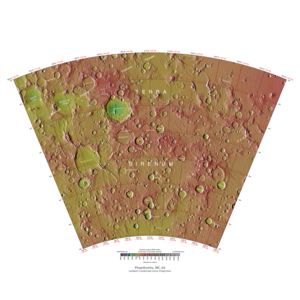
 Map of Phaethontis quadrangle from Mars Orbiter Laser Altimeter (MOLA) data. The highest elevations are red and the lowest are blue. | |
| Coordinates | 47°30′S 150°00′W / 47.5°S 150°W |
|---|---|

The Phaethontis quadrangle is one of a series of 30 quadrangle maps of Mars used by the United States Geological Survey (USGS) Astrogeology Research Program. The Phaethontis quadrangle is also referred to as MC-24 (Mars Chart-24).[1]
The name comes from Phaethon, the son of Helios.[2]
The Phaethontis quadrangle lies between 30° and 65° south latitude and 120° and 180° west longitude on Mars. This latitude range is where numerous gullies have been discovered. An old feature in this area, called Terra Sirenum lies in this quadrangle; Mars Reconnaissance Orbiter discovered iron/magnesium smectites there.[3] Part of this quadrangle contains what is called the Electris deposits, a deposit that is 100–200 metres (330–660 ft) thick. It is light-toned and appears to be weak because of few boulders.[4] Among a group of large craters is Mariner Crater, first observed by the Mariner 4 spacecraft in the summer of 1965. It was named after that spacecraft.[5][page needed] A low area in Terra Sirenum is believed to have once held a lake that eventually drained through Ma'adim Vallis.[6][7][8][page needed] Russia's Mars 3 probe landed in the Phaethontis quadrangle at 44.9° S and 160.1° W in December 1971. It landed at a speed of 75 km per hour, but survived to radio back 20 seconds of signal, then it went dead. Its message just appeared as a blank screen.[9][page needed]
- ^ Davies, M.E.; Batson, R.M.; Wu, S.S.C. (1992). "Geodesy and Cartography". In Kieffer, H.H.; Jakosky, B.M.; Snyder, C.W.; et al. (eds.). Mars. Tucson: University of Arizona Press. ISBN 978-0-8165-1257-7.
- ^ Blunck, J. 1982. Mars and its Satellites, Exposition Press. Smithtown, N.Y.
- ^ Murchie, S.; Mustard, John F.; Ehlmann, Bethany L.; Milliken, Ralph E.; et al. (2009). "A synthesis of Martian aqueous mineralogy after 1 Mars year of observations from the Mars Reconnaissance Orbiter" (PDF). Journal of Geophysical Research. 114 (E2): E00D06. Bibcode:2009JGRE..114.0D06M. doi:10.1029/2009JE003342.
- ^ Grant, J.; Wilson, Sharon A.; Noe Dobrea, Eldar; Fergason, Robin L.; et al. (2010). "HiRISE views enigmatic deposits in the Sirenum Fossae region of Mars". Icarus. 205 (1): 53–63. Bibcode:2010Icar..205...53G. doi:10.1016/j.icarus.2009.04.009.
- ^ Kieffer, Hugh H. (1992). Mars. Tucson: University of Arizona Press. ISBN 978-0-8165-1257-7.
- ^ "HiRISE | Light-toned Mounds in Gorgonum Basin (ESP_050948_1430)".
- ^ Irwin, Rossman P.; Howard, Alan D.; Maxwell, Ted A. (2004). "Geomorphology of Ma'adim Vallis, Mars, and associated paleolake basins". Journal of Geophysical Research. 109 (E12): 12009. Bibcode:2004JGRE..10912009I. doi:10.1029/2004JE002287.
- ^ Michael Carr (2006). The surface of Mars. Cambridge, UK: Cambridge University Press. ISBN 978-0-521-87201-0.
- ^ Hartmann, W. (2003). A Traveler's Guide to Mars. New York: Workman Publishing. ISBN 978-0-7611-2606-5.