Pickens County | |
|---|---|
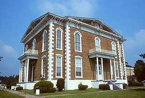
 Pickens County Courthouse in Carrollton | |
 Location within the U.S. state of Alabama | |
 Alabama's location within the U.S. | |
| Coordinates: 33°16′43″N 88°05′35″W / 33.278611111111°N 88.093055555556°W | |
| Country | |
| State | |
| Founded | December 20, 1820 |
| Named for | Andrew Pickens |
| Seat | Carrollton |
| Largest city | Aliceville |
| Area | |
| • Total | 890 sq mi (2,300 km2) |
| • Land | 881 sq mi (2,280 km2) |
| • Water | 8.7 sq mi (23 km2) 1.0% |
| Population (2020) | |
| • Total | 19,123 |
| • Estimate (2023) | 18,688 |
| • Density | 21/sq mi (8.3/km2) |
| Time zone | UTC−6 (Central) |
| • Summer (DST) | UTC−5 (CDT) |
| Congressional district | 7th |
| Website | www |
| |
Pickens County is a county located on the west central border of the U.S. state of Alabama. As of the 2020 census, the population was 19,123.[1] Its county seat is Carrollton, located in the center of the county.[2] It is a prohibition, or dry county, although the communities of Carrollton and Aliceville voted to become wet in 2011 and 2012, respectively.
Pickens County is included in the Tuscaloosa, AL Metropolitan Statistical Area
- ^ "State & County QuickFacts". United States Census Bureau. Retrieved September 10, 2023.
- ^ "Find a County". National Association of Counties. Retrieved June 7, 2011.