Picuris Pueblo, New Mexico | |
|---|---|
 San Lorenzo de Picurís | |
 Location of Picuris Pueblo, New Mexico | |
| Coordinates: 36°11′58″N 105°42′47″W / 36.19944°N 105.71306°W | |
| Country | United States |
| State | New Mexico |
| County | Taos |
| Area | |
| • Total | 0.46 sq mi (1.19 km2) |
| • Land | 0.46 sq mi (1.18 km2) |
| • Water | 0.00 sq mi (0.01 km2) |
| Elevation | 7,277 ft (2,218 m) |
| Population | |
| • Total | 83 |
| • Density | 181.62/sq mi (70.17/km2) |
| Time zone | UTC-7 (Mountain (MST)) |
| • Summer (DST) | UTC-6 (MDT) |
| Area code | 505 |
| FIPS code | 35-56810 |
| GNIS feature ID | 2409063[2] |
Picuris Pueblo | |
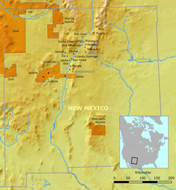
 Location of Picuris Pueblo and neighboring pueblos in New Mexico | |
| Nearest city | Taos, New Mexico |
|---|---|
| Area | 20.4 acres (8.3 ha) |
| Built | 1776 |
| Architectural style | Pueblo |
| NRHP reference No. | 74001211[4] |
| NMSRCP No. | 229 |
| Significant dates | |
| Added to NRHP | August 13, 1974 |
| Designated NMSRCP | December 30, 1971 |
Picuris Pueblo (/pɪkəˈriːs/; Tiwa: P'įwweltha [p’ī̃wːēltʰà]) is a historic pueblo in Taos County, New Mexico, United States. The federally recognized tribe of Pueblo people inhabit the community. Picurís Pueblo is a member of the Eight Northern Pueblos. Their own name for their pueblo is P'įwweltha, meaning "mountain warrior place" or "mountain pass place." They speak the Picuris dialect of the Northern Tiwa language, part of the Kiowa-Tanoan language family.[5] For statistical purposes, the United States Census Bureau has defined that community as a census-designated place (CDP). The 2010 census[6] estimated that 68 people lived in the CDP, while 267 people in the U.S. reported being of the tribal group Picuris alone[7] and 439 reported being of the tribal group Picuris alone or in combination with other groups.[8]
- ^ "ArcGIS REST Services Directory". United States Census Bureau. Retrieved October 12, 2022.
- ^ a b U.S. Geological Survey Geographic Names Information System: Picuris Pueblo, New Mexico
- ^ Cite error: The named reference
USCensusDecennial2020CenPopScriptOnlywas invoked but never defined (see the help page). - ^ "National Register Information System". National Register of Historic Places. National Park Service. July 9, 2010.
- ^ Cite error: The named reference
p58was invoked but never defined (see the help page). - ^ U.S. Census Bureau (2010). "NM - Picuris Pueblo CDP". United States Census 2010. Archived from the original on August 3, 2018. Retrieved March 8, 2018.
- ^ Census 2010 American Indian and Alaska Native Summary File (AIANSF) - Sample Data, Pueblo of Picuris alone (H47)
- ^ Census 2010 American Indian and Alaska Native Summary File (AIANSF) - Sample Data, Pueblo of Picuris alone or in any combination (H47) & (100-299) or (300, A01-Z99) or (400-999)
