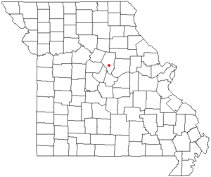
Pierpont, Missouri | |
|---|---|
| Village of Pierpont | |
 | |
| Country | United States |
| State | Missouri |
| County | Boone |
| Area | |
| • Total | 0.23 sq mi (0.59 km2) |
| • Land | 0.23 sq mi (0.59 km2) |
| • Water | 0.00 sq mi (0.00 km2) |
| Elevation | 768 ft (234 m) |
| Population (2020) | |
| • Total | 64 |
| • Density | 280.70/sq mi (108.30/km2) |
| FIPS code | 29-57512 |
| GNIS feature ID | 2399669[2] |
Pierpont is a village in Boone County, Missouri, United States.[3] It is part of the Columbia, Missouri Metropolitan Statistical Area. The population was 64 at the 2020 census. The village, located south of Rock Bridge Memorial State Park at Route N and Highway 163,[4] was incorporated in 2004 to avoid annexation by the city of Columbia. It is now an independent village with its own governing board of trustees.[5]
- ^ "ArcGIS REST Services Directory". United States Census Bureau. Retrieved August 28, 2022.
- ^ a b U.S. Geological Survey Geographic Names Information System: Pierpont, Missouri
- ^ U.S. Geological Survey Geographic Names Information System: Pierpont, Missouri
- ^ Ashland, Missouri, 7.5 Minute Topographic Quadrangle, USGS, 1969 (1982 rev.)
- ^ "Tinier towns hold onto identities as county develops". Columbia Daily Tribune. June 17, 2007. Archived from the original on September 27, 2007. Retrieved August 6, 2007.