| Piestewa Peak | |
|---|---|
| Vainom Do'ag | |
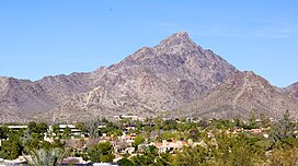
 Piestewa Peak viewed from Wrigley Mansion | |
| Highest point | |
| Elevation | 2,610 ft (796 m) NAVD 88[1] |
| Prominence | 1,176 ft (358 m)[2] |
| Coordinates | 33°32′50″N 112°01′16″W / 33.547332322°N 112.020989392°W[1] |
| Geography | |
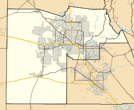
| Location | Maricopa County, Arizona, U.S. |
| Parent range | Phoenix Mountains |
| Topo map | USGS Sunnyslope |
| Geology | |
| Rock age | Precambrian |
| Mountain type | Schist |
| Climbing | |
| Easiest route | Walk up, class 1s3[3] |
Piestewa Peak (/paɪˈɛstəwɑː/ py-ES-tə-wah;[4] O'odham: Vainom Do'ag, formerly Squaw Peak), at 2,610 feet (796 m) is the second highest point in the Phoenix Mountains, after Camelback Mountain, and the third highest in the city of Phoenix, Arizona. It is located in the Piestewa Peak Recreation Area within the Phoenix Mountain Preserve, near Piestewa Freeway (Arizona State Highway 51). Piestewa Peak is named in honor of Army Spc. Lori Ann Piestewa, the first known Native American woman to die in combat in the U.S. military,[5] and the first female soldier to be killed in action in the 2003 Iraq War.[6]
- ^ a b "Squaw Peak Reset". NGS Data Sheet. National Geodetic Survey, National Oceanic and Atmospheric Administration, United States Department of Commerce. Retrieved 2009-12-01.
- ^ "Piestewa Peak, Arizona". Peakbagger.com. Retrieved 2010-12-31.
- ^ "Piestewa Peak". SummitPost.org. Retrieved 2014-02-08.
- ^ Pancrazio, Angela Cara (2003-05-26). "Piestewa is latest hard-to-pronounce name for Arizona". The Arizona Republic.
- ^ "Army Pfc. Lori Ann Piestewa". Military Times. Archived from the original on 2014-02-21. Retrieved 2014-02-08.
- ^ Davidson, Osha Gray (June 3, 2004). "The Forgotten Soldier, The unsung herione of the Jessica Lynch ambush in Iraq". Archived from the original on 2009-04-12. Retrieved 2014-02-08.


