| Pigeon River | |
|---|---|
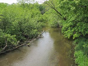
 The Pigeon River in Hemlock Crossing Park in Port Sheldon Township | |
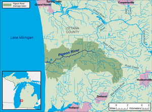
 A map of the Pigeon River and its watershed. | |
| Location | |
| Country | United States |
| State | Michigan |
| County | Ottawa |
| Townships | Olive, Port Sheldon |
| Physical characteristics | |
| Source | |
| • location | Olive Township |
| • coordinates | 42°55′09″N 86°02′41″W / 42.9191895°N 86.044766°W[2] |
| • elevation | 625 ft (191 m)[1] |
| Mouth | Lake Michigan |
• location | Port Sheldon Township |
• coordinates | 42°54′04″N 86°12′55″W / 42.9011315°N 86.2153253°W[2] |
• elevation | 581 ft (177 m)[2] |
| Length | 12.9 miles (20.8 km) |
| Basin size | 61.7 sq mi (160 km2) |
| Discharge | |
| • location | mouth |
| • average | 64.53 cu ft/s (1.827 m3/s) (estimate)[3] |
| Basin features | |
| Progression | Lake Michigan—Lake Huron—St. Clair—Lake St. Clair—Detroit—Lake Erie—Niagara—Lake Ontario—St. Lawrence—Atlantic Ocean |
| Tributaries | |
| • left | Sawyer Creek, Ten Hagen Creek |
| Waterbodies | Pigeon Lake |
| Hydrologic Unit Codes | 040500020302, 040500020303 (USGS) |
The Pigeon River is a small river flowing to Lake Michigan on the western Lower Peninsula of the U.S. state of Michigan. The river is approximately 12.9 miles (20.8 km) long[4][a] and drains an area of 61.7 square miles (160 km2)[6][b] in a generally rural area situated between the cities of Holland and Grand Haven. Via Lake Michigan and the larger Great Lakes system, it is part of the watershed of the St. Lawrence River.
- ^ The National Map elevation query for coordinates given in cited GNIS record, http://viewer.nationalmap.gov/viewer/. Retrieved on 2016-10-16.
- ^ a b c U.S. Geological Survey Geographic Names Information System: Pigeon River
- ^ United States Environmental Protection Agency. "Watershed Report: Pigeon River". WATERS GeoViewer. Archived from the original on 2021-07-14. Retrieved 2021-07-14.
- ^ U.S. Geological Survey. National Hydrography Dataset high-resolution flowline data from The National Map, accessed 2016-10-16 and viewed in ArcMap.
- ^ a b Pigeon River Watershed Advisory Committee (August 1997). "Pigeon River Watershed Project, Ottawa County, Michigan: Comprehensive Nonpoint Source Watershed Management Plan" (PDF). Archived from the original (PDF) on 2016-08-16. Retrieved 2016-10-16.
- ^ U.S. Geological Survey. National Hydrography Dataset, area data covering Pigeon River watershed (12-digit Hydrologic Unit Codes 040500020302 and 040500020303), viewed in The National Map, accessed 2016-10-13.
Cite error: There are <ref group=lower-alpha> tags or {{efn}} templates on this page, but the references will not show without a {{reflist|group=lower-alpha}} template or {{notelist}} template (see the help page).