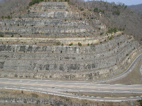
The Pikeville Cut-Through is a rock cut in Pikeville, Kentucky, United States, created by the U.S. Army Corps of Engineers, through which passes a four-lane divided highway (Corridor B, numbered as U.S. Route 23 (US 23), US 119, US 460, and KY 80), a railroad line (CSX' Big Sandy Subdivision), and the Levisa Fork of the Big Sandy River.[1] It is one of the largest civil engineering projects in the Western Hemisphere. Nearly 18,000,000 cubic yards (14,000,000 m3)[1] of soil and rock were moved, making the Pikeville Cut-Through second only to the Panama Canal (240,000,000 cubic yards (180,000,000 m3)) when ranking the hemisphere's largest earth-moving projects.[2] Dr. William Hambley, who served as mayor of Pikeville for 29 years, Robert H. Holcomb, Chamber of Commerce president, and Henry Stratton, local attorney, spearheaded the project.

The Pikeville Cut-Through is 1,300 feet (400 m) wide, 3,700 feet (1.1 km) long, and 523 feet (159 m) deep.[1] The project was completed in 1987 following 14 years of work at a cost of $77.6 million ($208 million in 2023 dollars[3]).
- ^ a b c Maddox, Connie. The Pikeville Cut-Through Project (brochure). Pikeville-Pike County Tourism. Retrieved on June 17, 2010
- ^ Flow Diversion-Pikeville Cut-Through University of Kentucky. Retrieved on November 22, 2010.
- ^ 1634–1699: McCusker, J. J. (1997). How Much Is That in Real Money? A Historical Price Index for Use as a Deflator of Money Values in the Economy of the United States: Addenda et Corrigenda (PDF). American Antiquarian Society. 1700–1799: McCusker, J. J. (1992). How Much Is That in Real Money? A Historical Price Index for Use as a Deflator of Money Values in the Economy of the United States (PDF). American Antiquarian Society. 1800–present: Federal Reserve Bank of Minneapolis. "Consumer Price Index (estimate) 1800–". Retrieved February 29, 2024.