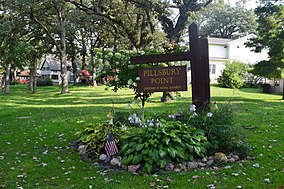
| Pillsbury Point State Park | |
|---|---|
 Sign at the park's entrance | |
| Location | Dickinson, Iowa, United States |
| Coordinates | 43°22′03″N 95°08′29.5″W / 43.36750°N 95.141528°W |
| Area | 6.48 acres (2.62 ha) |
| Elevation | 1,424 ft (434 m)[1] |
| Established | 1933 |
| Governing body | Iowa Department of Natural Resources |
 One of the boundary markers. | |
| Area | 1.5 acres (0.61 ha) |
| Built | 1933-1934 |
| Architect | Central Design Office, Ames |
| Architectural style | Rustic |
| MPS | CCC Properties in Iowa State Parks MPS |
| NRHP reference No. | 90001674[2] |
| Added to NRHP | January 12, 1993 |
Pillsbury Point State Park is located in Arnolds Park, Iowa, United States. It is Iowa's smallest state park and unlike the others, it is an urban park.[3] At 6.48 acres (2.62 ha), it is a narrow park that extends along a point of land into West Okoboji Lake adjacent to private summer houses.[4] The overlook at the north end of the park was listed on the National Register of Historic Places in 1990.[2] The historic designation includes walkways along the lake, stone steps, stone benches, and property boundary markers.
- ^ "Pillsbury Point State Park". Geographic Names Information System. United States Geological Survey. April 30, 1979. Retrieved May 30, 2016.
- ^ a b "National Register Information System". National Register of Historic Places. National Park Service. July 9, 2010.
- ^ Rebecca Conard. "Pillsbury Point State Park Overlook District". National Park Service. Retrieved May 30, 2016. with seven photos from c. 1990
- ^ Joyce McKay. "Gull Point State Park: Area A". National Park Service. Retrieved May 31, 2016.

