Pinawa | |
|---|---|
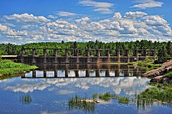
 Decommissioned hydroelectric dam at old Pinawa on the Lee River | |
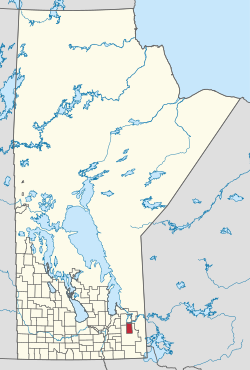
 Pinawa is a small local government district located just north of the Rural Municipality of Whitemouth (the latter being highlighted in red) | |
| Country | Canada |
| Province | Manitoba |
| Region | Eastman |
| Government | |
| • MP (Selkirk—Interlake—Eastman) | James Bezan (CPC) |
| Area | |
| • Total | 1.55 km2 (0.60 sq mi) |
| Population (2016) | |
| • Total | 1,331[1] |
| • Density | 856.1/km2 (2,217/sq mi) |
| • Change 2011–16 | |
| Time zone | UTC-6 (CST) |
| • Summer (DST) | UTC-5 (CDT) |
Pinawa is a local government district and small community of 1,331 residents (2016 census) located in southeastern Manitoba, Canada. It is 110 kilometres north-east of Winnipeg. The town is situated on the Canadian Shield within the western boundary of Whiteshell Provincial Park, which lies near the Manitoba-Ontario provincial boundary. Administratively, the town includes the surrounding area, and is officially the Local Government District of Pinawa. Except for a small eastern border with the unorganized area of the Eastman Region, it is surrounded by the Rural Municipalities of Lac du Bonnet to the north and Whitemouth to the south, but is independent of either one. The community lies on the north bank of the Winnipeg River in the southeastern part of the Local Government District.
- ^ "Census Profile, 2016 Census". Statistics Canada. 2017-04-14. Retrieved 2017-05-06.