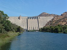
| Pine Flat Dam | |
|---|---|
 Pine Flat Dam in Fresno County, California | |
| Country | United States |
| Location | Fresno County, California, U.S. |
| Coordinates | 36°49′56″N 119°19′34″W / 36.83222°N 119.32611°W |
| Status | Operational |
| Construction began | 1947 |
| Opening date | 1954 |
| Owner(s) | |
| Dam and spillways | |
| Type of dam | Concrete gravity |
| Impounds | Kings River |
| Height | 440 ft (130 m)[1] |
| Length | 1,840 ft (560 m)[1] |
| Reservoir | |
| Creates | Pine Flat Lake |
| Total capacity | 1,000,000 acre⋅ft (1.2 km3)[2] |
| Inactive capacity | 45,379 acre⋅ft (0.055974 km3)[3] |
| Catchment area | 1,545 sq mi (4,000 km2)[2] |
| Surface area | 5,970 acres (2,420 ha)[2] |
| Maximum water depth | 429 ft (131 m) |
| Normal elevation | 955 ft (291 m) (max)[4] |
| Power Station | |
| Operator(s) | Kings River Conservation District |
| Hydraulic head | 424 ft (129 m)[1] |
| Turbines | 3x 55MW Francis |
| Installed capacity | 165 MW[5] |
| Annual generation | 387,256,000 KWh (2001–2012)[6] |
| Website U.S. Army Corps of Engineers - Pine Flat Lake Project | |
Pine Flat Dam is a concrete gravity dam on the Kings River in the Central Valley of Fresno County, California United States. Situated about 28 miles (45 km) east of Fresno, the dam is 440 feet (130 m) high and impounds Pine Flat Lake, in the foothills of the Sierra Nevada just outside the boundary of Kings Canyon National Park. The dam's primary purpose is flood control, with irrigation, hydroelectric power generation and recreation secondary in importance.
The dam was built by the U.S. Army Corps of Engineers (USACE) after a six-year controversy between supporters of irrigation development and proponents of flood control. Construction began in 1947 and was completed in 1954. Since then, the dam has prevented millions of dollars in flood damages and fostered extensive development of agriculture on the fertile floodplain of the Kings River; after 1984 it has also generated hydroelectricity. The increased irrigation allowed by the dam has also led to the destruction of some of North America's most extensive wetland habitats.
- ^ a b c "Pine Flat Dam: Detailed Information". National Inventory of Dams. U.S. Army Corps of Engineers. Retrieved April 1, 2012.
- ^ a b c "Pine Flat Dam (PNF)". California Data Exchange Center. California Department of Water Resources. Retrieved April 1, 2012.
- ^ Ritzema, Randall S.; Newlin, Brad D.; Van Lienden, Brian J. (October 2001). "Appendix H: Infrastructure" (PDF). CALVIN Project. University of California Davis. Archived from the original (PDF) on November 6, 2017. Retrieved January 25, 2014.
- ^ "Pine Flat Lake". Geographic Names Information System. United States Geological Survey, United States Department of the Interior. August 1, 1990. Retrieved April 1, 2012.
- ^ "Pine Flat Power Plant". Kings River Conservation District. Retrieved April 1, 2012.
- ^ "California Hydroelectric Statistics & Data". California Energy Commission. Archived from the original on February 26, 2018. Retrieved April 26, 2018.