| Piney Woods | |
|---|---|
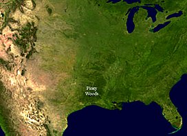
 Satellite image of North America with the Piney Woods eco-region discernible in distinct dark green. | |
 South Central Plains (EPA ecoregion) | |
| Ecology | |
| Realm | Nearctic |
| Biome | Temperate coniferous forest |
| Borders | |
| Bird species | 205[1] |
| Mammal species | 60[1] |
| Geography | |
| Area | 140,900 km2 (54,400 sq mi) |
| Country | United States |
| States | |
| Coordinates | 32°N 94°W / 32°N 94°W |
| Climate type | Humid subtropical (Cfa) |
| Conservation | |
| Habitat loss | 22.235%[1] |
| Protected | 11.03%[1] |
The Piney Woods is a temperate coniferous forest terrestrial ecoregion in the Southern United States covering 54,400 square miles (141,000 km2) of East Texas, southern Arkansas, western Louisiana, and southeastern Oklahoma. These coniferous forests are dominated by several species of pine as well as hardwoods including hickory and oak. Historically the most dense part of this forest region was the Big Thicket though the lumber industry dramatically reduced the forest concentration in this area and throughout the Piney Woods during the 19th and 20th centuries. The World Wide Fund for Nature considers the Piney Woods to be one of the critically endangered ecoregions of the United States.[2] The United States Environmental Protection Agency (EPA) defines most of this ecoregion as the South Central Plains.
- ^ a b c d Hoekstra, J. M.; Molnar, J. L.; Jennings, M.; Revenga, C.; Spalding, M. D.; Boucher, T. M.; Robertson, J. C.; Heibel, T. J.; Ellison, K. (2010). Molnar, J. L. (ed.). The Atlas of Global Conservation: Changes, Challenges, and Opportunities to Make a Difference. University of California Press. ISBN 978-0-520-26256-0.
- ^ "Piney Woods forests". Terrestrial Ecoregions. World Wildlife Fund. Retrieved 2009-06-14.