| Ping River | |
|---|---|
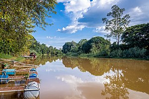
 Ping River at Chiang Mai in October 2020. | |
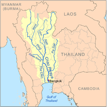
 Map of the Chao Phraya River drainage basin showing the Ping River | |
| Location | |
| Country | Thailand |
| District | Chiang Mai, Lamphun, Tak, Kamphaeng Phet, Nakhon Sawan |
| Cities | Chiang Mai, Saraphi, San Sai, Kamphaeng Phet, Banphot Phisai |
| Physical characteristics | |
| Source | Khun Ping[1] |
| • location | Doi Thuai, Chiang Mai |
| • coordinates | 19°48′45″N 98°50′20″E / 19.81250°N 98.83889°E |
| • elevation | 1,700 m (5,600 ft) |
| Mouth | Chao Phraya River |
• location | Pak Nam Pho, Nakhon Sawan |
• coordinates | 15°42′04″N 100°08′31″E / 15.701°N 100.142°E |
• elevation | 25 m (82 ft) |
| Length | 658 km (409 mi) |
| Basin size | 44,688 km2 (17,254 sq mi) |
| Discharge | |
| • location | Nakhon Sawan |
| • average | 265 m3/s (9,400 cu ft/s) |
| • maximum | 2,302 m3/s (81,300 cu ft/s) |
| Basin features | |
| Progression | Chao Phraya → Gulf of Thailand |
| Tributaries | |
| • left | Ngad River, Kwuang River, Li River, Wang River |
| • right | Taeng River, Chaem River |
The Ping River (Thai: แม่น้ำปิง, RTGS: Maenam Ping, pronounced [mɛ̂ː.náːm pīŋ]; Northern Thai: น้ำแม่ปิง, pronounced [nâːm mɛ̂ː.pīŋ]) along with the Nan River, is one of the two main tributaries of the Chao Phraya River.[2] It originates at Doi Thuai in the Daen Lao Range, in Chiang Dao district, Chiang Mai province. After passing Chiang Mai, it flows through the provinces of Lamphun, Tak and Kamphaeng Phet. At the confluence with the Nan at Nakhon Sawan (also named Paknam Pho in Thai), it forms the Chao Phraya River.
- ^ "Chiang Dao National Park". Thai Forest Booking. Retrieved 2009-05-20.
- ^ "Mae Ping River: Lifeline of Chiangmai Province". Chiangmai and Chiangrai Magazine. 2008. Archived from the original on 2009-11-29. Retrieved 2009-04-02.