Pirganj Upazila | |
|---|---|
Pirganj, Rangpur | |
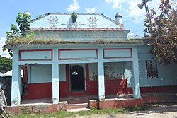
 Dargah of Shah Ismail Ghazi | |
 | |
| Coordinates: 25°24.9′N 89°19′E / 25.4150°N 89.317°E | |
| Country | |
| Division | Rangpur |
| District | Rangpur |
| Government | |
| • Chief Executive Officer | Khadija Begum |
| Area | |
| • Total | 411.35 km2 (158.82 sq mi) |
| Population | |
| • Total | 414,845 |
| • Density | 1,000/km2 (2,600/sq mi) |
| Time zone | UTC+6 (BST) |
| Postal code | 5470[2] |
| Area code | 05227[3] |
| Website | pirgonj |
Pirganj (Bengali: পীরগঞ্জ) is an upazila of Rangpur District in the division of Rangpur, Bangladesh. Pirganj Upazila area 411.35 km2, located in between 25°18' and 25°31' north latitudes and in between 89°08' and 89°25' east longitudes. It is bounded by Mithapukur Upazila on the north, Palashbari Upazila on the south, Ghoraghat Upazila and Nawabganj Upazila on the west, Sadullapur Upazila on the east.
Administration Pirganj Thana, now an upazila, was formed in 1910.
- ^ National Report (PDF). Population and Housing Census 2022. Vol. 1. Dhaka: Bangladesh Bureau of Statistics. November 2023. p. 403. ISBN 978-9844752016.
- ^ "Bangladesh Postal Code". Dhaka: Bangladesh Postal Department under the Department of Posts and Telecommunications of the Ministry of Posts, Telecommunications and Information Technology of the People's Republic of Bangladesh. 21 October 2024.
- ^ "Bangladesh Area Code". Stockholm, Sweden: Rebtel.com. 18 October 2024.