Pishan County
Guma | |
|---|---|
 | |
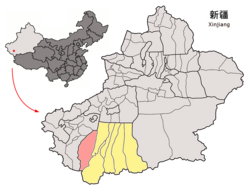
 Location of Pishan/Guma County (red) within Hotan Prefecture (yellow) and Xinjiang | |
| Coordinates: 37°37′N 78°17′E / 37.62°N 78.28°E | |
| Country | China |
| Autonomous region | Xinjiang |
| Prefecture | Hotan |
| County seat | Guma Town |
| Area | |
| • Total | 39,741.52 km2 (15,344.29 sq mi) |
| Population (2020)[3] | |
| • Total | 281,573 |
| • Density | 7.1/km2 (18/sq mi) |
| Ethnic groups | |
| • Major ethnic groups | Uyghur[4][5] |
| Time zone | UTC+8 (China Standard[a]) |
| Postal code | 845100 |
| Website | www |
| Pishan County | |||||||||||
|---|---|---|---|---|---|---|---|---|---|---|---|
| Uyghur name | |||||||||||
| Uyghur | گۇما ناھىيىسى | ||||||||||
| |||||||||||
| Chinese name | |||||||||||
| Simplified Chinese | 皮山县 | ||||||||||
| Traditional Chinese | 皮山縣 | ||||||||||
| |||||||||||
| Alternative Chinese name | |||||||||||
| Simplified Chinese | 固玛县 | ||||||||||
| Traditional Chinese | 固瑪縣 | ||||||||||
| |||||||||||
Pishan County (Chinese: 皮山县) as the official romanized name, also transliterated from Uyghur as Guma County (Uyghur: گۇما ناھىيىسى; Chinese: 固玛县), is a county within the Xinjiang Uyghur Autonomous Region and is under the administration of the Hotan Prefecture. It contains an area of 39,412 km2 (15,217 sq mi). According to the 2002 census, it has a population of 220,000. The county borders Maralbexi County and Makit County to the north, Karakax County, Hotan County and Kunyu to the east and Kargilik County to the west. The county includes lands near the Karakoram Pass which are part of the Aksai Chin area that is disputed between China and India.
- ^ Cite error: The named reference
xzqhgumawas invoked but never defined (see the help page). - ^ Cite error: The named reference
cihaiwas invoked but never defined (see the help page). - ^ Xinjiang: Prefectures, Cities, Districts and Counties
- ^ Cite error: The named reference
gaikuangwas invoked but never defined (see the help page). - ^ 1997年皮山县行政区划 [1997 Guma County Administrative Divisions]. XZQH.org. 6 January 2011. Retrieved 3 April 2020.
面积41167平方千米,人口20.2万,有维吾尔、汉、塔吉克、柯尔克孜等民族,辖2镇13乡。{...}有维吾尔、汉等民族。{...},均系维吾尔族。{...}有维吾尔、柯尔克孜等民族,
Cite error: There are <ref group=lower-alpha> tags or {{efn}} templates on this page, but the references will not show without a {{reflist|group=lower-alpha}} template or {{notelist}} template (see the help page).


