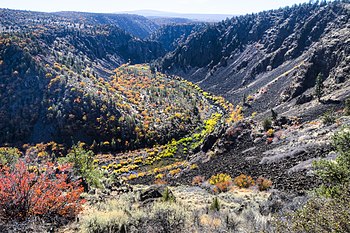
| Pit River | |
|---|---|
 Waterfalls on the Pit River near Fall River Mills | |
 Map of the Pit River drainage basin, with the historically connected Goose Lake drainage basin indicated in orange.[1] | |
| Etymology | Achomawi pitfall traps[2] |
| Location | |
| Country | United States |
| State | California |
| District | Modoc, Lassen, & Shasta counties |
| Physical characteristics | |
| Source | Confluence of North and South Forks |
| • location | Near Alturas, Modoc County |
| • coordinates | 41°28′23″N 120°33′28″W / 41.47306°N 120.55778°W[3] |
| • elevation | 4,350 ft (1,330 m) |
| Mouth | Sacramento River |
• location | Shasta Lake, Shasta County |
• coordinates | 40°45′23″N 122°22′14″W / 40.75639°N 122.37056°W[3] |
• elevation | 1,066 ft (325 m) |
| Length | 207 mi (333 km)[4] |
| Basin size | 7,064 sq mi (18,300 km2)[5]: a |
| Discharge | |
| • location | Montgomery Creek, above Shasta Lake[6] |
| • average | 4,786 cu ft/s (135.5 m3/s)[6] |
| • minimum | 30 cu ft/s (0.85 m3/s) |
| • maximum | 73,000 cu ft/s (2,100 m3/s) |
| Basin features | |
| Tributaries | |
| • left | Ash Creek |
| • right | Sulanharas Creek, McCloud River |

The Pit River is a major river draining from northeastern California into the state's Central Valley.[3] The Pit, the Klamath and the Columbia are the only three rivers in the U.S. that cross the Cascade Range.
The longest tributary of the Sacramento River, it contributes as much as eighty percent of their combined water volume into the Shasta Lake reservoir; the junction of their Shasta Lake arms is 4 miles (6.4 km) northeast of Shasta Dam. The main stem of the Pit River is 207 miles (333 km) long,[4] and some water in the system flows 265 miles (426 km) to the Sacramento River measuring from the Pit River's longest source.[7][8]
The Pit River drains a sparsely populated volcanic highlands area in Modoc County's Warner Mountains, passing through the south end of the Cascade Range in a deep canyon northeast of Redding. The river is so named because of the semi-subterranean permanent winter homes and large 'sweat houses' that the Pit River Tribe dug,[9] and their pit traps for game that came to water at the river.[10]
The river is a popular destination for fishing, fly fishing, and rafting in its lower reaches, and is used to generate hydroelectricity in the powerhouses below Fall River Mills where the Pit and Fall rivers join, and at Shasta Dam. It is also used extensively for irrigation and conservation purposes.
- ^ "Welcome to the Pit River Watershed Alliance". Pit River Watershed Alliance. Archived from the original on 2014-01-03. Retrieved 2014-04-27.
- ^ Secrest 2003, p. 236.
- ^ a b c "Pit River". Geographic Names Information System. United States Geological Survey, United States Department of the Interior. 1981-01-19. Retrieved 2014-04-26.
- ^ a b U.S. Geological Survey. National Hydrography Dataset high-resolution flowline data. The National Map, accessed 2011-03-10
- ^ "Boundary Descriptions and Names of Regions, Subregions, Accounting Units and Cataloging Units". USGS.gov. Retrieved 2010-09-21.
a. "sum of USGS watershed values (Lower Pit + McCloud + Upper Pit + Goose Lake)". Google Calculator. Retrieved 2010-09-23. - ^ a b "USGS Gage #11365000 on the Pit River near Montgomery Creek, CA" (PDF). National Water Information System. U.S. Geological Survey. 1966–2012. Retrieved 2014-04-26.
- ^ "USGS National Atlas Streamer". United States Geological Survey. Archived from the original on 2014-05-28. Retrieved 2016-11-19.
- ^ "Watersheds in Modoc County, California" (Watersheds map with URL list). Surf Your Watershed. U.S. Environmental Protection Agency. Retrieved 2010-09-21.
- ^ Kniffen, Fred B. (1928). "Achumawi Geography". University of California Publications in American Archaeology and Ethnology. 23 (5). Berkeley: University of California: 297–332.
- ^ Neasham, Ernest (1985). Fall River Valley An Examination of Historical Sources. Sacramento CA: The Citadel Press. p. 10.