Pitcairn Islands Pitkern Ailen (Pitcairn-Norfolk) | |
|---|---|
| Pitcairn, Henderson, Ducie and Oeno Islands | |
| Anthem: "God Save the King" | |
| Local anthem: "Come Ye Blessed" | |
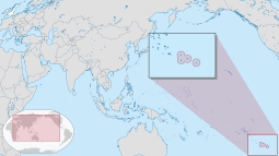
 Map showing location of the Pitcairn Islands (circled at the lower-right and magnified in an inset) | |
| Sovereign state | |
| Settlement | 15 January 1790 |
| British colony | 30 November 1838 |
| Capital and largest settlement | Adamstown[note 1] 25°04′S 130°06′W / 25.067°S 130.100°W |
| Official languages | |
| Ethnic groups | Pitcairn Islanders |
| Demonym(s) |
|
| Government | Devolved locally governing dependency |
• Monarch | Charles III |
• Governor | Iona Thomas |
| Lindsy Thompson[2] | |
• Mayor | Simon Young |
| Legislature | Island Council |
| Government of the United Kingdom | |
• Minister | Stephen Doughty |
| Area | |
• Total | 47 km2 (18 sq mi) (not ranked) |
| Highest elevation | 330 m (1,080 ft) |
| Population | |
• 2023 estimate | 34[3] (last) |
• Density | 0.74/km2 (1.9/sq mi) (not ranked) |
| GDP (nominal) | 2005 estimate |
• Total | NZ$217,000[4] |
• Per capita | NZ$4,617.02 |
| Currency | New Zealand dollar (NZ$)[a] (NZD) |
| Time zone | UTC-08:00 |
| Driving side | left |
| Calling code | +64 |
| UK postcode | PCRN 1ZZ |
| ISO 3166 code | PN |
| Internet TLD | .pn |
| Website | www.government.pn |
| |
The Pitcairn Islands (/ˈpɪtkɛərn/ PIT-kairn;[5] Pitkern: Pitkern Ailen), officially Pitcairn, Henderson, Ducie and Oeno Islands,[6][7][8][9] are a group of four volcanic islands in the southern Pacific Ocean that form the sole British Overseas Territory in the Pacific Ocean. The four islands—Pitcairn, Henderson, Ducie and Oeno—are scattered across several hundred kilometres of ocean and have a combined land area of about 47 square kilometres (18 square miles). Henderson Island accounts for 86% of the land area, but only Pitcairn Island is inhabited. The inhabited islands nearest to the Pitcairn Islands are Mangareva (of French Polynesia), 688 km to the west,[note 2] as well as Easter Island, 1,929 km to the east.
The Pitcairn Islanders are a biracial ethnic group descended mostly from nine Bounty mutineers and a handful of Tahitian consorts. As of 2023, the territory had only 35 permanent inhabitants.[3]
- ^ "United Kingdom Overseas Territories – Toponymic Information" (PDF). Present Committee on Geographic Names. pp. 4–5/6. Retrieved 10 February 2024. – Hosted on the Government of the United Kingdom website.
- ^ "Minutes of the Regular council Meeting held at the Pulau school" (PDF). Pitcairn Island Council. 24 April 2024.
- ^ a b "Life on Pitcairn — Pitcairn Island Immigration". Government of the Pitcairn Islands. 2023. Retrieved 18 July 2024.
- ^ "Pitcairn Islands Strategic Development Plan, 2012–2016" (PDF). The Government of the Pitcairn Islands. 2013. p. 4. Archived from the original (PDF) on 5 July 2015.
Gross Domestic Product (GDP) . . . NZ$217,000 (2005/06 indicative estimate) and NZ$4,340 per capita (based on 50 residents)
- ^ Oxford English Dictionary
- ^ "British Nationality Act 1981 – SCHEDULE 6 British Overseas Territories". UK Government. September 2016. Archived from the original on 12 April 2018. Retrieved 21 September 2016.
- ^ "Pitcairn Constitution Order 2010 – Section 2 and Schedule 1, Section 6" (PDF). UK Government. September 2016. Archived (PDF) from the original on 10 September 2016. Retrieved 8 October 2015.
- ^ "Laws of Pitcairn, Henderson, Ducie and Oeno Islands". Pitcairn Island Council. September 2016. Archived from the original on 29 January 2018. Retrieved 8 April 2012.
- ^ "The Overseas Territories" (PDF). UK Government. September 2016. Archived (PDF) from the original on 20 October 2017. Retrieved 21 September 2016.
Cite error: There are <ref group=note> tags on this page, but the references will not show without a {{reflist|group=note}} template (see the help page).

