Placetas | |
|---|---|
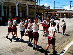
 OPJM pioneers in town center | |
| Nickname: La Villa de los Laureles (Laurel City) | |
 Placetas municipality (red) within Villa Clara Province (yellow) and Cuba | |
| Coordinates: 22°18′57″N 79°39′20″W / 22.31583°N 79.65556°W | |
| Country | Cuba |
| Province | Villa Clara |
| Established | 1861[1] |
| Incorporated | 1881 (town) |
| 1925 (city) | |
| Area | |
| 601 km2 (232 sq mi) | |
| Elevation | 205 m (673 ft) |
| Population (2022)[3] | |
| 65,379 | |
| • Density | 110/km2 (280/sq mi) |
| • Urban | 19,894 |
| • Rural | 45,485 |
| Time zone | UTC-5 (EST) |
| Area code | +53-428 |
| Highways | Carretera Central |
Placetas (Spanish pronunciation: [plaˈsetas]) is a city in the Villa Clara Province in the center of Cuba; before the change in the country's government in 1959 the province was called Las Villas. The town is also known as La Villa de los Laureles because of its wild laurel trees. Placetas is also a municipio, one of 13 subdivisions of the Villa Clara Province. Cuba's geographical center, Guaracabulla, is located in this municipality.
