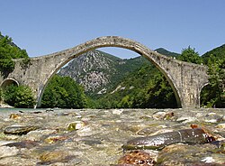
Plaka Bridge Γεφύρι Πλάκας | |
|---|---|
 The bridge in 2011 | |
| Coordinates | 39°27′38″N 21°01′48″E / 39.46056°N 21.03000°E |
| Carried | Pedestrian (Footbridge) |
| Crossed | Arachthos River |
| Locale | Arta and Ioannina, Greece |
| Owner | Hellenic Ministry of Culture and Sports |
| Characteristics | |
| Material | Stone |
| Total length | 61 metres (200 ft) or 75 metres (246 ft) |
| Width | 3.20 metres (10.5 ft) |
| Height | 21 m (68 ft 11 in) |
| No. of spans | 1 |
| Piers in water | 2 |
| History | |
| Opened | 1866 |
| Collapsed | 1860, 1863, 2015 |
| Location | |
 | |
Plaka Bridge (Greek: Γεφύρι της Πλάκας, Gefýri tis Plákas) is a 19th-century stone one-arch bridge in Greece that collapsed during the floods of 1 February 2015, and was rebuilt in 2020.
It is located at the borders of Arta and Ioannina prefectures, above the waters of Arachthos River. Administratively, it belongs to the community of Plaka-Raftaneon.[1] With its arch of 40 metres (130 ft) width and 17.61 m (57 ft 9 in) height,[1] it was the largest one-arch bridge in Greece[2][failed verification] and the Balkans,[3][4] and the third largest one-arch stone bridge in Europe.[5][failed verification] It also had two small auxiliary arches of 6 metres (20 ft) width on its two sides.[6] It was considered "one of the most difficult, single-arch bridges to construct."[4][irrelevant citation]
The bridge was the starting point for rafting and canoeing on Arachthos River.
- ^ a b Leftheris et al. (2006), p. 148
- ^ "Plaka Bridge". odysseus.culture.gr. Retrieved 1 February 2015.
- ^ "Greece to restore Ottoman-era bridge". Anadolu Agency. 2 January 2015. Retrieved 2 January 2015.
- ^ a b "Floods bring down Ottoman bridge in Balkans". Hürriyet Daily News. 2 January 2015. Retrieved 2 January 2015.
- ^ "Κατσανοχώρια: Εξώστης στον Αραχθο". ethnos.gr (in Greek). Ethnos Online. Retrieved 1 February 2015.
- ^ Cite error: The named reference
Ministrywas invoked but never defined (see the help page).