| Platte River | |
|---|---|
 Platte River at Mahoney State Park | |
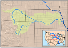
 Map showing the Platte River watershed, including the North Platte and South Platte tributaries | |
| Etymology | French ("flat river") and Chiwere ("flat water") |
| Location | |
| Country | United States |
| State | Nebraska |
| Region | Great Plains |
| Cities | North Platte, Kearney, Grand Island, Fremont, Omaha |
| Physical characteristics | |
| Source | North Platte River |
| • location | Confluence of Grizzly Creek and Little Grizzly Creek, Jackson County, Colorado |
| • coordinates | 40°38′23″N 106°24′19″W / 40.63972°N 106.40528°W[2] |
| • length | 716 mi (1,152 km) |
| • elevation | 8,050 ft (2,450 m) |
| 2nd source | South Platte River |
| • location | Confluence of Middle Fork and South Fork South Platte Rivers, Park County, Colorado |
| • coordinates | 39°00′40″N 105°44′25″W / 39.01111°N 105.74028°W[3] |
| • length | 439 mi (707 km) |
| • elevation | 8,785 ft (2,678 m) |
| Source confluence | |
| • location | Near North Platte, Lincoln County, Nebraska |
| • coordinates | 41°06′50″N 100°40′33″W / 41.11389°N 100.67583°W[1] |
| • elevation | 2,762 ft (842 m)[2] |
| Mouth | Missouri River |
• location | Cass / Sarpy counties, at Plattsmouth, Nebraska |
• coordinates | 41°03′14″N 95°52′53″W / 41.05389°N 95.88139°W[1] |
• elevation | 942 ft (287 m)[1] |
| Length | 310 mi (500 km), West-east |
| Basin size | 84,910 sq mi (219,900 km2)[4] |
| Discharge | |
| • location | Louisville, 10 miles (16 km) above the mouth[5] |
| • average | 7,037 cu ft/s (199.3 m3/s)[5] |
| • minimum | 131 cu ft/s (3.7 m3/s) |
| • maximum | 160,000 cu ft/s (4,500 m3/s) |
| Basin features | |
| River system | Missouri River basin |
| Tributaries | |
| • left | North Platte River, Loup River, Elkhorn River |
| • right | South Platte River |
 | |
The Platte River (/plæt/) is a major American river, in the state of Nebraska. It is about 310 mi (500 km) long; measured to its farthest source via its tributary, the North Platte River, it flows for over 1,050 miles (1,690 km). The Platte River is a tributary of the Missouri River, which itself is a tributary of the Mississippi River which flows to the Gulf of Mexico. The Platte over most of its length is a broad, shallow, meandering stream with a sandy bottom and many islands—a braided stream.
The Platte is one of the most significant tributary systems in the watershed of the Missouri, draining a large portion of the central Great Plains in Nebraska and the eastern Rocky Mountains in Colorado and Wyoming. The river valley played an important role in the westward expansion of the United States, providing the route for several major emigrant trails, including the Oregon, California, Mormon and Bozeman trails. The first Europeans to see the Platte were French explorers and fur trappers about 1714; they first called it the Nebraskier (Nebraska), a transliteration of the name given by the Otoe people, meaning "flat water". This expression is very close to the French words "rivière platte" ("flat river"), the probable origin of the name Platte River.
- ^ a b c d e "Platte River". Geographic Names Information System. United States Geological Survey, United States Department of the Interior. Retrieved 2010-10-03.
- ^ a b "North Platte River". Geographic Names Information System. United States Geological Survey, United States Department of the Interior. Retrieved 2010-10-03.
- ^ "South Platte River". Geographic Names Information System. United States Geological Survey, United States Department of the Interior. Retrieved 2010-10-03.
- ^ "Boundary Descriptions and Names of Regions, Subregions, Accounting Units and Cataloging Units". U.S. Geological Survey. Retrieved 2010-10-03.
- ^ a b "USGS Gage #06801000 on the Platte River near Louisville, Nebraska (Water-Data Report 2009)" (PDF). National Water Information System. U.S. Geological Survey. 2009. Retrieved 2010-10-03.