Plogonnec
Plogoneg | |
|---|---|
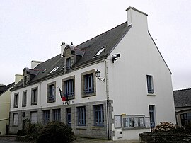
 Town hall or Mairie | |
| Coordinates: 48°04′43″N 4°11′35″W / 48.0786°N 4.1931°W | |
| Country | France |
| Region | Brittany |
| Department | Finistère |
| Arrondissement | Quimper |
| Canton | Quimper-1 |
| Intercommunality | Quimper Bretagne Occidentale |
| Government | |
| • Mayor (2020–2026) | Didier Leroy[1] |
Area 1 | 54.14 km2 (20.90 sq mi) |
| Population (2021)[2] | 3,210 |
| • Density | 59/km2 (150/sq mi) |
| Time zone | UTC+01:00 (CET) |
| • Summer (DST) | UTC+02:00 (CEST) |
| INSEE/Postal code | 29169 /29180 |
| Elevation | 12–286 m (39–938 ft) |
| 1 French Land Register data, which excludes lakes, ponds, glaciers > 1 km2 (0.386 sq mi or 247 acres) and river estuaries. | |
Plogonnec (French pronunciation: [plɔɡɔnɛk]; Breton: Plogoneg) is a commune and small town in the Finistère department of Brittany in north-western France. It is about 13 km (8 mi) north west of Quimper and 10 km (6 mi) east of Douarnenez. The town is twinned with Llandysul in Wales.
- ^ "Répertoire national des élus: les maires". data.gouv.fr, Plateforme ouverte des données publiques françaises (in French). 9 August 2021.
- ^ "Populations légales 2021" (in French). The National Institute of Statistics and Economic Studies. 28 December 2023.


