| Plum Creek | |
|---|---|
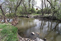
 Ingalls Family Dugout Site on the banks of Plum Creek | |
| Etymology | wild plum (Prunus americana) |
| Native name | Kaŋtaota (Dakota) |
| Location | |
| Country | United States |
| State | Minnesota |
| County | Redwood, Murray |
| Physical characteristics | |
| Source | |
| • coordinates | 44°10′33″N 95°36′08″W / 44.1757923°N 95.6022311°W |
| Mouth | |
• location | Cottonwood River |
• coordinates | 44°14′57″N 95°27′50″W / 44.2492°N 95.4639°W |
| Length | 35.4 mi (57.0 km) |
| Basin features | |
| Progression | Cottonwood→ Minnesota→ Mississippi→ Gulf of Mexico |
| River system | Minnesota River |
Plum Creek[1] is a 35.4-mile-long (57.0 km)[2] stream near the city of Walnut Grove, Minnesota. It passes to the northwest of the town, flowing northeasterly to the Cottonwood River, with its waters then flowing to the Minnesota River and eventually the Mississippi River. Plum Creek lends its name to a regional library network.
- ^ U.S. Geological Survey Geographic Names Information System: Plum Creek (Cottonwood River tributary)
- ^ U.S. Geological Survey. National Hydrography Dataset high-resolution flowline data. The National Map, accessed October 5, 2012
