| Plum Creek | |
|---|---|
 Plum Creek | |
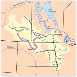
 The Red River drainage basin, with the Souris River highlighted | |
| Location | |
| Countries | Canada |
| Provinces | Manitoba |
| Towns | Souris |
| Physical characteristics | |
| Source | Plum Lakes |
| • location | Manitoba |
| Mouth | Souris River, at the community of Souris |
• location | Manitoba |
• coordinates | 49°36′51″N 100°15′20″W / 49.61417°N 100.25556°W |
| Discharge | |
| • location | Souris River |
| Basin features | |
| River system | Red River drainage basin |
Plum Creek[1] is the primary outflow for the Plum Lakes (49°37′51″N, 100°43′39″W)[2] and travels in an easterly direction for about 28 kilometres until it meets up with the Souris River, which is part of the Hudson Bay drainage basin, at the community of Souris in the Canadian province of Manitoba.[3] Plum Lakes and the beginning of Plum Creek are in the Rural Municipality of Sifton and the mouth is in the Municipality of Souris – Glenwood.
- ^ Government of Canada, Natural Resources Canada. "Place names - Plum Creek". www4.rncan.gc.ca.
- ^ Government of Canada, Natural Resources Canada. "Place names - Plum Lakes". www4.rncan.gc.ca.
- ^ "Welcome to Souris-Glenwood". sourismanitoba. Retrieved 2 November 2021.

