Plymouth, New Hampshire | |
|---|---|
Town | |
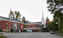
 Town center (left to right): Plymouth Post Office, Rounds Hall of Plymouth State University (in background), Plymouth Congregational Church, Town Hall | |
| Motto(s): Bridging the Lakes Region and the White Mountains | |
 Location in Grafton County, New Hampshire | |
| Coordinates: 43°45′27″N 71°41′19″W / 43.75750°N 71.68861°W | |
| Country | United States |
| State | New Hampshire |
| County | Grafton |
| Incorporated | 1763 |
| Named for | Plymouth Colony, Massachusetts |
| Villages |
|
| Government | |
| • Selectboard |
|
| • Town Manager | Scott Weden |
| Area | |
• Total | 28.6 sq mi (74.2 km2) |
| • Land | 28.1 sq mi (72.8 km2) |
| • Water | 0.5 sq mi (1.4 km2) 1.94% |
| Elevation | 520 ft (160 m) |
| Population (2020)[2] | |
• Total | 6,682 |
| • Density | 238/sq mi (91.8/km2) |
| Time zone | UTC−5 (Eastern) |
| • Summer (DST) | UTC−4 (Eastern) |
| ZIP Code | 03264 |
| Area code | 603 |
| FIPS code | 33-62660 |
| GNIS feature ID | 0873702 |
| Website | www |
Plymouth is a New England town in Grafton County, New Hampshire, United States, in the White Mountains Region. It has a unique role as the economic, medical, commercial, and cultural center for the predominantly rural Plymouth, NH Labor Market Area.[3] Plymouth is located at the confluence of the Pemigewasset and Baker rivers and sits at the foot of the White Mountains. The town's population was 6,682 at the 2020 census.[2] It is home to Plymouth State University, Speare Memorial Hospital, and Plymouth Regional High School.
The town's main center, where 4,730 people resided at the 2020 census (three-quarters of whom are college student age),[4] is defined as the Plymouth census-designated place (CDP), and is located along U.S. Route 3, south of the confluence of the Baker and Pemigewasset rivers.
Plymouth State University, in the center of town, has a total undergraduate population of 3,336 students and a total graduate population of 503 students as of the 2023/2024 academic year.[5]
- ^ "2021 U.S. Gazetteer Files – New Hampshire". United States Census Bureau. Retrieved November 30, 2021.
- ^ a b "Plymouth town, Grafton County, New Hampshire: 2020 DEC Redistricting Data (PL 94-171)". U.S. Census Bureau. Retrieved November 30, 2021.
- ^ "Regional Transportation Plan: 2015" (PDF). North Country Council.
- ^ "Profile of General Population and Housing Characteristics (DP-1): Plymouth CDP, New Hampshire". American Factfinder. U.S. Census Bureau. Archived from the original on February 13, 2020. Retrieved November 8, 2019.
- ^ "Plymouth State University: Common Data Set 2023/2024" (PDF). Plymouth State University. 2024. Retrieved June 3, 2024.
