蒲台島 | |
|---|---|
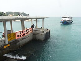
 Tsui Wah Ferry vessel arriving at Po Toi public pier | |
 Location of Po Toi Island within Hong Kong | |
| Geography | |
| Area | 3.69 km2 (1.42 sq mi) |
| Administration | |
| Po Toi | |||||||||||||
|---|---|---|---|---|---|---|---|---|---|---|---|---|---|
| Traditional Chinese | 蒲台島 | ||||||||||||
| Simplified Chinese | 蒲台岛 | ||||||||||||
| |||||||||||||
| Alternative Chinese name | |||||||||||||
| Traditional Chinese | 蒲苔島 | ||||||||||||
| Simplified Chinese | 蒲苔岛 | ||||||||||||
| |||||||||||||


Po Toi (commonly Chinese: 蒲台島, originally Chinese: 蒲苔島) is the main island of the Po Toi Islands and the southernmost[1] island of Hong Kong, with an area of 3.69 km2.[2]
- ^ "LCQ11: Public facilities on Po Toi Island". www.info.gov.hk. Retrieved 3 December 2021.
- ^ Lands Department (February 2011), Hong Kong Geographic Data (PDF), retrieved 26 November 2011