Pohatcong Township, New Jersey | |
|---|---|
 Springtown Stagecoach Inn, listed on the National Register of Historic Places | |
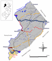
 Location of Pohatcong Township in Warren County highlighted in yellow (right). Inset map: Location of Warren County in New Jersey highlighted in black (left). | |
 Census Bureau map of Pohatcong Township, New Jersey | |
Location in Warren County Location in New Jersey | |
| Coordinates: 40°38′11″N 75°10′30″W / 40.636483°N 75.174906°W[1] | |
| Country | |
| State | |
| County | |
| Incorporated | January 1, 1882 |
| Government | |
| • Type | Faulkner Act |
| • Body | Township Council |
| • Mayor | David S. Slack (term ends December 31, 2023)[2][3] |
| • Municipal clerk | Wanda L. Kutzman[4] |
| Area | |
• Total | 13.76 sq mi (35.63 km2) |
| • Land | 13.37 sq mi (34.63 km2) |
| • Water | 0.39 sq mi (1.00 km2) 2.81% |
| • Rank | 179th of 565 in state 13th of 22 in county[1] |
| Elevation | 253 ft (77 m) |
| Population | |
• Total | 3,241 |
• Estimate (2023)[8] | 3,276 |
| • Rank | 439th of 565 in state 12th of 22 in county[9] |
| • Density | 242.4/sq mi (93.6/km2) |
| • Rank | 492nd of 565 in state 13th of 22 in county[9] |
| Time zone | UTC−05:00 (Eastern (EST)) |
| • Summer (DST) | UTC−04:00 (Eastern (EDT)) |
| ZIP Code | |
| Area code | 908[12] |
| FIPS code | 34-59820[1][13][14] |
| GNIS feature ID | 882254[1][6] |
| School district | Phillipsburg School District |
| Website | www |
Pohatcong Township is a township in Warren County, in the U.S. state of New Jersey.[15] As of the 2020 United States census, the township's population was 3,241,[7] a decrease of 98 (−2.9%) from the 2010 census count of 3,339,[16][17] which in turn reflected a decline of 77 (−2.3%) from the 3,416 counted in the 2000 census.[18]
The name Pohatcong is thought to be derived from the Lenni Lenape Native American term meaning "stream between split hills".[19]
- ^ a b c d e 2019 Census Gazetteer Files: New Jersey Places, United States Census Bureau. Accessed July 1, 2020.
- ^ Cite error: The named reference
Officialswas invoked but never defined (see the help page). - ^ 2023 New Jersey Mayors Directory, New Jersey Department of Community Affairs, updated February 8, 2023. Accessed February 10, 2023.
- ^ Municipal Clerk, Pohatcong Township. Accessed June 21, 2022.
- ^ Cite error: The named reference
DataBookwas invoked but never defined (see the help page). - ^ a b "Township of Pohatcong (Warren County, New Jersey)". Geographic Names Information System. United States Geological Survey. Retrieved May 15, 2014.
- ^ a b Cite error: The named reference
LWD2020was invoked but never defined (see the help page). - ^ Cite error: The named reference
PopEstwas invoked but never defined (see the help page). - ^ a b Population Density by County and Municipality: New Jersey, 2020 and 2021, New Jersey Department of Labor and Workforce Development. Accessed March 1, 2023.
- ^ Look Up a ZIP Code for Bloomsbury, NJ, United States Postal Service. Accessed June 14, 2013.
- ^ Look Up a ZIP Code for Phillipsburg, NJ, United States Postal Service. Accessed June 14, 2013.
- ^ Area Code Lookup - NPA NXX for Phillipsburg, NJ, Area-Codes.com. Accessed October 20, 2014.
- ^ U.S. Census website, United States Census Bureau. Accessed September 4, 2014.
- ^ Geographic Codes Lookup for New Jersey, Missouri Census Data Center. Accessed April 1, 2022.
- ^ Lurie, M.N.; Siegel, M.; Mappen, M. (2004). Encyclopedia of New Jersey. Rutgers University Press. p. 646. ISBN 978-0-8135-3325-4. Retrieved July 4, 2019.
- ^ Cite error: The named reference
Census2010was invoked but never defined (see the help page). - ^ Cite error: The named reference
LWD2010was invoked but never defined (see the help page). - ^ Table 7. Population for the Counties and Municipalities in New Jersey: 1990, 2000 and 2010, New Jersey Department of Labor and Workforce Development, February 2011. Accessed May 1, 2023.
- ^ About Archived September 27, 2012, at the Wayback Machine, Pohatcong Township. Accessed June 14, 2013. "Pohatcong Township whose Lenni Lenape name is said to mean 'stream between split hills' is located in the picturesque northwest New Jersey and is in the center of the Highlands Region spanning four states- New Jersey, Pennsylvania, New York and Connecticut."


