Point Arena | |
|---|---|
 Point Arena and its lighthouse | |
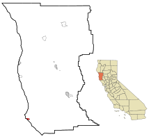
 Location in Mendocino County and California | |
| Coordinates: 38°54′32″N 123°41′35″W / 38.90889°N 123.69306°W | |
| Country | |
| State | |
| County | Mendocino |
| Incorporated | July 11, 1908[1] |
| Area | |
• Total | 1.36 sq mi (3.5 km2) |
| • Land | 1.36 sq mi (3.5 km2) |
| • Water | 0.00 sq mi (0.0 km2) 0% |
| Elevation | 118 ft (36 m) |
| Population | |
• Total | 460 |
| • Density | 337.0/sq mi (130.1/km2) |
| Time zone | UTC-8 (PST) |
| • Summer (DST) | UTC-7 (PDT) |
| ZIP code | 95468 |
| Area code | 707 |
| FIPS code | 06-57876 |
| GNIS feature ID | 1659411 |
| Website | pointarena |
Point Arena, formerly known as Punta Arena (Spanish for "Sandy Point")[3] is a small coastal city in Mendocino County, California, United States. Point Arena is located 32 miles (51 km) west of Hopland,[5] at an elevation of 118 feet (36 m).[3] The population was 460 at the 2020 census,[4] making it one of the smallest incorporated cities in the state.
Its main street is part of State Route 1, California's coastal artery. Along with a number of other Mendocino County coastal communities, Point Arena was associated with the hippie and subsequent counterculture groups. The economy is largely geared toward serving the summertime tourist industry. The city is near the headquarters of the tribal lands of the Manchester Band of Pomo Indians of the Manchester Rancheria and adjacent to the recently formed Point Arena-Stornetta Public Lands National Monument. Hiking trails with coastal prairie and ocean views can be accessed from Point Arena City Hall. At Arena Cove Historic District and pier, huge oceanfront bluffs show the power of the interface of tectonic plates.
- ^ "California Cities by Incorporation Date". California Association of Local Agency Formation Commissions. Archived from the original (Word) on November 3, 2014. Retrieved August 25, 2014.
- ^ "2021 U.S. Gazetteer Files: California". United States Census Bureau. Retrieved July 28, 2022.
- ^ a b c U.S. Geological Survey Geographic Names Information System: Point Arena, California
- ^ a b "P1. Race – Point Arena city, California: 2020 DEC Redistricting Data (PL 94-171)". U.S. Census Bureau. Retrieved July 28, 2022.
- ^ Durham, David L. (1998). California's Geographic Names: A Gazetteer of Historic and Modern Names of the State. Clovis, Calif.: Word Dancer Press. p. 124. ISBN 1-884995-14-4.
