Point Wells | |
|---|---|
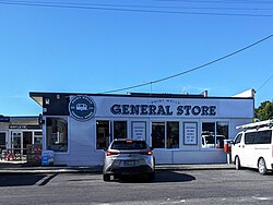
 Point Wells general store | |
 | |
| Coordinates: 36°19′19″S 174°45′25″E / 36.322°S 174.757°E | |
| Country | New Zealand |
| Region | Auckland Region |
| Ward | Rodney ward |
| Community board | Rodney Local Board |
| Subdivision | Warkworth subdivision |
| Electorates | |
| Government | |
| • Territorial Authority | Auckland Council |
| Area | |
• Total | 0.80 km2 (0.31 sq mi) |
| Population (June 2024)[2] | |
• Total | 600 |
| • Density | 750/km2 (1,900/sq mi) |
Point Wells is a rural settlement in the Auckland Region of New Zealand, at the tip of a peninsula between the Ōmaha River and Whangateau Harbour. Ōmaha is across the harbour but accessible by a causeway.[3]
Point Wells was divided into sections in 1947 when a local farmer sold off some of his land. It grew slowly, and in the late 1960s the development of Ōmaha drew most of the new builds away.[4]
Point Wells Hall was built in 1956 on donated land. It included a community library for many years. In 2008, the community gave control of running the hall to Rodney District Council, and two years later when Auckland Council was established it took the responsibility. In 2018, Auckland Council handed back the management to a subcommittee of the Point Wells Community and Ratepayers Association.[5]
- ^ Cite error: The named reference
Areawas invoked but never defined (see the help page). - ^ "Aotearoa Data Explorer". Statistics New Zealand. Retrieved 26 October 2024.
- ^ Harriss, Gavin (March 2022). Point Wells, Auckland (Map). NZ Topo Map.
- ^ Glenny, Helen (September 2021). "About Town: Point Wells". North & South.
- ^ "Hall is back in community hands". Auckland Council. 6 June 2018.